

warrington to parkgate
A cycling route starting in Appleton, England, United Kingdom.
Overview
About this route
warrington to action bridge delamere chester mollington parkgate
- -:--
- Duration
- 71.3 km
- Distance
- 214 m
- Ascent
- 290 m
- Descent
- ---
- Avg. speed
- ---
- Max. altitude
Continue with Bikemap
Use, edit, or download this cycling route
You would like to ride warrington to parkgate or customize it for your own trip? Here is what you can do with this Bikemap route:
Free features
- Save this route as favorite or in collections
- Copy & plan your own version of this route
- Sync your route with Garmin or Wahoo
Premium features
Free trial for 3 days, or one-time payment. More about Bikemap Premium.
- Navigate this route on iOS & Android
- Export a GPX / KML file of this route
- Create your custom printout (try it for free)
- Download this route for offline navigation
Discover more Premium features.
Get Bikemap PremiumFrom our community
Other popular routes starting in Appleton
 313–343 London Road, Warrington to Knutsford Road, Antrobus, Northwich
- Distance
- 8.3 km
- Ascent
- 24 m
- Descent
- 29 m
- Location
- Appleton, England, United Kingdom
 Kanaha, Cann Lane South, Warrington to Kanaha, Cann Lane South, Warrington
- Distance
- 21.5 km
- Ascent
- 76 m
- Descent
- 73 m
- Location
- Appleton, England, United Kingdom
 10 Stonehill Close, Warrington to 10 Stonehill Close, Warrington
- Distance
- 22.2 km
- Ascent
- 120 m
- Descent
- 122 m
- Location
- Appleton, England, United Kingdom
 Bawm House, Cann Lane S, Warrington to The Swallows, Cann Lane S, Warrington
- Distance
- 21.9 km
- Ascent
- 140 m
- Descent
- 133 m
- Location
- Appleton, England, United Kingdom
 The Swallows, Cann Lane S, Warrington to The Swallows, Cann Lane S, Warrington
- Distance
- 14.8 km
- Ascent
- 53 m
- Descent
- 52 m
- Location
- Appleton, England, United Kingdom
 Pineways, Warrington to Pineways, Warrington
- Distance
- 21.9 km
- Ascent
- 184 m
- Descent
- 183 m
- Location
- Appleton, England, United Kingdom
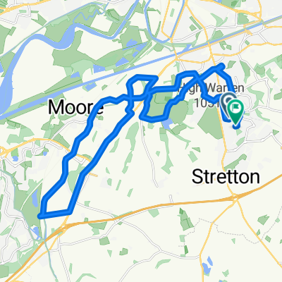
 Hatton daresbury higher Whitley Antrobus home
- Distance
- 23.2 km
- Ascent
- 78 m
- Descent
- 119 m
- Location
- Appleton, England, United Kingdom
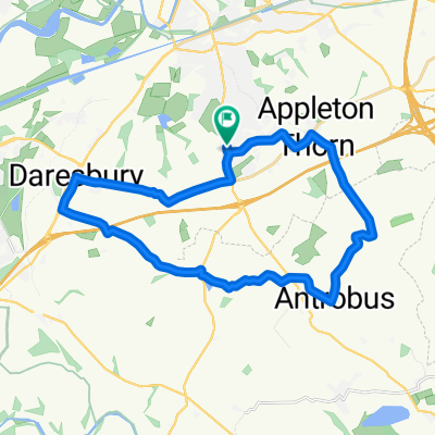
 higher Whitley and Antrobus
- Distance
- 21.6 km
- Ascent
- 37 m
- Descent
- 104 m
- Location
- Appleton, England, United Kingdom
Open it in the app