

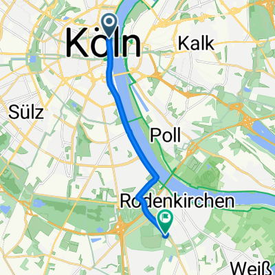
Kölner Randkanal
A cycling route starting in Altstadt Nord, North Rhine-Westphalia, Germany.
Overview
About this route
Pegel_Kölner-Randkanal
Länge: 37 km Pegel BASTEI Ebertplatz Maybachstraße SATURN Media Park Stadtgarten Universtätstraße Danteweg folgen den Radweg Kölner Stadtwald Müngersdorf Alter Militäring Lövenich Kölner Randkanal Folgen bis Otto Lindenthal-Straße Widdesdorf WDR Militäring West-Friedehof Ossendorf Blücherpark Friesenplatz ENDE Einkehr Friesenplatz- -:--
- Duration
- 36.4 km
- Distance
- 80 m
- Ascent
- 78 m
- Descent
- ---
- Avg. speed
- 81 m
- Avg. speed

Route quality
Waytypes & surfaces along the route
Waytypes
Path
19.7 km
(54 %)
Quiet road
5.2 km
(14 %)
Surfaces
Paved
23.6 km
(65 %)
Unpaved
12 km
(33 %)
Asphalt
20.8 km
(57 %)
Gravel
11.4 km
(31 %)
Route highlights
Points of interest along the route
Point of interest after 1.7 km
ADFC Köln Melchiorstraße
Continue with Bikemap
Use, edit, or download this cycling route
You would like to ride Kölner Randkanal or customize it for your own trip? Here is what you can do with this Bikemap route:
Free features
- Save this route as favorite or in collections
- Copy & plan your own version of this route
- Sync your route with Garmin or Wahoo
Premium features
Free trial for 3 days, or one-time payment. More about Bikemap Premium.
- Navigate this route on iOS & Android
- Export a GPX / KML file of this route
- Create your custom printout (try it for free)
- Download this route for offline navigation
Discover more Premium features.
Get Bikemap PremiumFrom our community
Other popular routes starting in Altstadt Nord
 Im rechtsrheinischen Grüngürtel
- Distance
- 30.8 km
- Ascent
- 77 m
- Descent
- 67 m
- Location
- Altstadt Nord, North Rhine-Westphalia, Germany
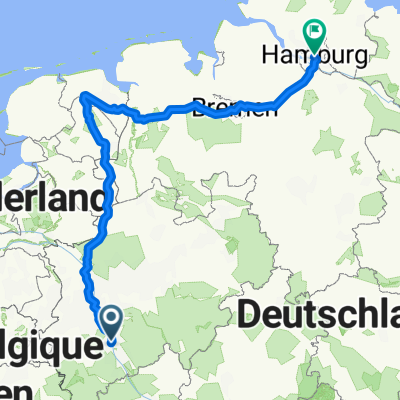 Köln-Hamburg
- Distance
- 628.6 km
- Ascent
- 1,061 m
- Descent
- 1,116 m
- Location
- Altstadt Nord, North Rhine-Westphalia, Germany
 Marienfeld / Papsthügel
- Distance
- 56.6 km
- Ascent
- 190 m
- Descent
- 185 m
- Location
- Altstadt Nord, North Rhine-Westphalia, Germany
 Köln . kleine Rheinrunde
- Distance
- 25.9 km
- Ascent
- 130 m
- Descent
- 130 m
- Location
- Altstadt Nord, North Rhine-Westphalia, Germany
 Forstbotanischer Garten, Köln
- Distance
- 7.5 km
- Ascent
- 41 m
- Descent
- 34 m
- Location
- Altstadt Nord, North Rhine-Westphalia, Germany
 CYCLING THE RHINE: Route 10A
- Distance
- 65.9 km
- Ascent
- 147 m
- Descent
- 138 m
- Location
- Altstadt Nord, North Rhine-Westphalia, Germany
 Königsdorf
- Distance
- 35.2 km
- Ascent
- 82 m
- Descent
- 71 m
- Location
- Altstadt Nord, North Rhine-Westphalia, Germany
 Breite - A4 - Deutz - Zoobrücke - Hbf
- Distance
- 20.5 km
- Ascent
- 141 m
- Descent
- 145 m
- Location
- Altstadt Nord, North Rhine-Westphalia, Germany
Open it in the app