

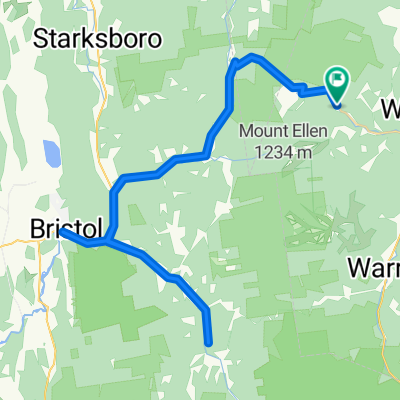
Bristol-LincolnGap-WestHill-AppGap
A cycling route starting in Bristol, Vermont, United States.
Overview
About this route
West Hill Rd is gravel.
- -:--
- Duration
- 58.9 km
- Distance
- 1,218 m
- Ascent
- 1,217 m
- Descent
- ---
- Avg. speed
- ---
- Max. altitude
Route quality
Waytypes & surfaces along the route
Waytypes
Road
24.7 km
(42 %)
Quiet road
4.1 km
(7 %)
Undefined
30 km
(51 %)
Surfaces
Paved
52.4 km
(89 %)
Unpaved
6.5 km
(11 %)
Asphalt
52.4 km
(89 %)
Gravel
6.5 km
(11 %)
Continue with Bikemap
Use, edit, or download this cycling route
You would like to ride Bristol-LincolnGap-WestHill-AppGap or customize it for your own trip? Here is what you can do with this Bikemap route:
Free features
- Save this route as favorite or in collections
- Copy & plan your own version of this route
- Sync your route with Garmin or Wahoo
Premium features
Free trial for 3 days, or one-time payment. More about Bikemap Premium.
- Navigate this route on iOS & Android
- Export a GPX / KML file of this route
- Create your custom printout (try it for free)
- Download this route for offline navigation
Discover more Premium features.
Get Bikemap PremiumFrom our community
Other popular routes starting in Bristol
 Bristol-LincolnGap-WestHill-AppGap
- Distance
- 58.9 km
- Ascent
- 1,218 m
- Descent
- 1,217 m
- Location
- Bristol, Vermont, United States
 Vermont - Classic
- Distance
- 115.3 km
- Ascent
- 1,312 m
- Descent
- 1,318 m
- Location
- Bristol, Vermont, United States
 02-MRB2 Avril 2017
- Distance
- 88.2 km
- Ascent
- 542 m
- Descent
- 542 m
- Location
- Bristol, Vermont, United States
 2009 GMSR Stage 3 - Mad River Road Race
- Distance
- 123.3 km
- Ascent
- 1,354 m
- Descent
- 1,107 m
- Location
- Bristol, Vermont, United States
 MRB3
MRB3- Distance
- 70 km
- Ascent
- 1,271 m
- Descent
- 1,271 m
- Location
- Bristol, Vermont, United States
 Mary Yates-Hills
- Distance
- 39.2 km
- Ascent
- 700 m
- Descent
- 698 m
- Location
- Bristol, Vermont, United States
 03-MRB3 - AVRIL 2017
- Distance
- 80.8 km
- Ascent
- 789 m
- Descent
- 789 m
- Location
- Bristol, Vermont, United States
 GMSR RR - Classic Course
- Distance
- 103.5 km
- Ascent
- 1,336 m
- Descent
- 1,079 m
- Location
- Bristol, Vermont, United States
Open it in the app