

Sobotnia Wycieczka Rowerowa
A cycling route starting in Łomianki, Masovian Voivodeship, Poland.
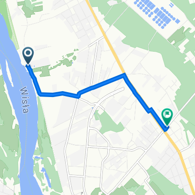
Overview
About this route
Route for 13.07 Me + Moni + Karol + Gaba: start from Łomianki from my place. Time: around 9:30. On the way, we cross the Vistula at Turkawką at 10:10. Agu + Młyncia (?): start from Chotomów. I suggest around 9:45. We meet in the picnic area near PKP Choszczówka probably around 10:30 and take a short break there before we continue towards Nieporęt. After soaking our feet in the Zegrzyński reservoir and eating fries at a scandalous price, we move along the picturesque and comfortable Royal Route along the Żerański Canal, admiring this child of Polish-Soviet friendship but above all nature, including for example the poplars gnawed by beavers. Then towards the Vistula for the ferry crossing. At the ferry crossing, we give each other a kiss goodbye and then head off in our respective directions.
- -:--
- Duration
- 53.2 km
- Distance
- 79 m
- Ascent
- 78 m
- Descent
- ---
- Avg. speed
- ---
- Max. altitude

Continue with Bikemap
Use, edit, or download this cycling route
You would like to ride Sobotnia Wycieczka Rowerowa or customize it for your own trip? Here is what you can do with this Bikemap route:
Free features
- Save this route as favorite or in collections
- Copy & plan your own version of this route
- Sync your route with Garmin or Wahoo
Premium features
Free trial for 3 days, or one-time payment. More about Bikemap Premium.
- Navigate this route on iOS & Android
- Export a GPX / KML file of this route
- Create your custom printout (try it for free)
- Download this route for offline navigation
Discover more Premium features.
Get Bikemap PremiumFrom our community
Other popular routes starting in Łomianki
 Jupiter - Veturilo i autobus Aluzyjna
- Distance
- 1.8 km
- Ascent
- 0 m
- Descent
- 0 m
- Location
- Łomianki, Masovian Voivodeship, Poland
 Łaki i pola :)
- Distance
- 9.3 km
- Ascent
- 9 m
- Descent
- 19 m
- Location
- Łomianki, Masovian Voivodeship, Poland
 MTB Mazovia 2010 - Łomianki 03.10.2010 (Epilog)
- Distance
- 54.2 km
- Ascent
- 90 m
- Descent
- 88 m
- Location
- Łomianki, Masovian Voivodeship, Poland
 Kępa Tarchomińska 1, Warszawa do Józefa Mehoffera 84, Warszawa
- Distance
- 3.5 km
- Ascent
- 3 m
- Descent
- 6 m
- Location
- Łomianki, Masovian Voivodeship, Poland
 Po-wale
- Distance
- 12.6 km
- Ascent
- 13 m
- Descent
- 18 m
- Location
- Łomianki, Masovian Voivodeship, Poland
 Sobotnia Wycieczka Rowerowa
- Distance
- 53.2 km
- Ascent
- 79 m
- Descent
- 78 m
- Location
- Łomianki, Masovian Voivodeship, Poland
 Chata Trapera - Nowy Dwór - Chata Trapera
- Distance
- 55.2 km
- Ascent
- 52 m
- Descent
- 53 m
- Location
- Łomianki, Masovian Voivodeship, Poland
 P.Kampinos_Dąbrowa-Roztoka-Zaborów_09.05.09
- Distance
- 64.7 km
- Ascent
- 109 m
- Descent
- 109 m
- Location
- Łomianki, Masovian Voivodeship, Poland
Open it in the app