

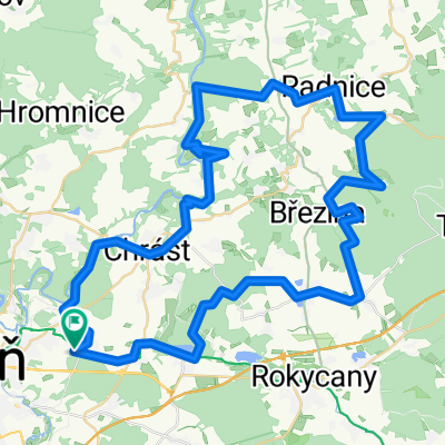
Lipovka, Krkavec (po zelené)
A cycling route starting in Dýšina, Plzeň Region, Czechia.
Overview
About this route
Lipovka, Krkavec (on green)... From Červený Hrádek to the town, then Kalikovský mill, Devil's pulpit, Radčice, Chotíkov, descent to Kůští, Čemíny (descent), ascent (nice, through the forest, alongside the Čemíny stream) over Košetice to the KV road, then descent to Všeruby, woodland path to the finish of the stage - woodland restaurant Lipovka. Back via Nekmíř to the junction at Doubrava, then on green towards Kokořov (nice descent), Stýskaly, Přísov, Ledce, and on green ascent (nutritious) to Krkavec. Down on red, and around the ponds back to Červený Hrádek.
- -:--
- Duration
- 64.9 km
- Distance
- 589 m
- Ascent
- 593 m
- Descent
- ---
- Avg. speed
- ---
- Max. altitude
Route quality
Waytypes & surfaces along the route
Waytypes
Track
27.3 km
(42 %)
Road
9.7 km
(15 %)
Surfaces
Paved
11 km
(17 %)
Unpaved
29.2 km
(45 %)
Unpaved (undefined)
13.6 km
(21 %)
Asphalt
8.4 km
(13 %)
Continue with Bikemap
Use, edit, or download this cycling route
You would like to ride Lipovka, Krkavec (po zelené) or customize it for your own trip? Here is what you can do with this Bikemap route:
Free features
- Save this route as favorite or in collections
- Copy & plan your own version of this route
- Sync your route with Garmin or Wahoo
Premium features
Free trial for 3 days, or one-time payment. More about Bikemap Premium.
- Navigate this route on iOS & Android
- Export a GPX / KML file of this route
- Create your custom printout (try it for free)
- Download this route for offline navigation
Discover more Premium features.
Get Bikemap PremiumFrom our community
Other popular routes starting in Dýšina
 Červený Hrádek, podél Berounky, přírodní park Radeč, Červený Hrádek
- Distance
- 68 km
- Ascent
- 817 m
- Descent
- 814 m
- Location
- Dýšina, Plzeň Region, Czechia
 Přes 7 vrcholů plzeňska
- Distance
- 105.1 km
- Ascent
- 1,473 m
- Descent
- 1,473 m
- Location
- Dýšina, Plzeň Region, Czechia
 okruh Červený Hrádek - Kokotsko
- Distance
- 26.3 km
- Ascent
- 470 m
- Descent
- 470 m
- Location
- Dýšina, Plzeň Region, Czechia
 Červený Hrádek, Rokycany, Dobřív, Holoubkov, Volduchy, Osek, Kokotské rybníky, Kyšice, Červený Hrádek
- Distance
- 63.5 km
- Ascent
- 626 m
- Descent
- 625 m
- Location
- Dýšina, Plzeň Region, Czechia
 Pohodnice, Čilina, Kotel, Radeč
- Distance
- 56.7 km
- Ascent
- 835 m
- Descent
- 851 m
- Location
- Dýšina, Plzeň Region, Czechia
 Lipovka, Krkavec (po zelené)
- Distance
- 64.9 km
- Ascent
- 589 m
- Descent
- 593 m
- Location
- Dýšina, Plzeň Region, Czechia
 Červený Hrádek, Berounka trail, Senec, Krkavec, Hracholusky, Dobřany, Červený Hrádek
- Distance
- 93.6 km
- Ascent
- 603 m
- Descent
- 603 m
- Location
- Dýšina, Plzeň Region, Czechia
 Červený Hrádek, Padrťské rybníky, Červený Hrádek
- Distance
- 99 km
- Ascent
- 829 m
- Descent
- 826 m
- Location
- Dýšina, Plzeň Region, Czechia
Open it in the app