

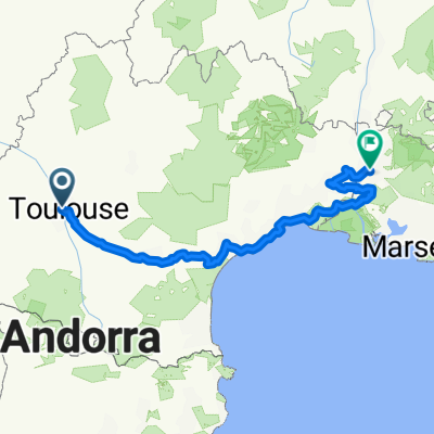
France 2013 - stage 1
A cycling route starting in Blagnac, Occitanie, France.
Overview
About this route
France 2013 - stage 1
- -:--
- Duration
- 33.7 km
- Distance
- 103 m
- Ascent
- 41 m
- Descent
- ---
- Avg. speed
- ---
- Max. altitude
Route quality
Waytypes & surfaces along the route
Waytypes
Quiet road
3.7 km
(11 %)
Cycleway
3.7 km
(11 %)
Surfaces
Paved
23.3 km
(69 %)
Asphalt
23.3 km
(69 %)
Undefined
10.5 km
(31 %)
Continue with Bikemap
Use, edit, or download this cycling route
You would like to ride France 2013 - stage 1 or customize it for your own trip? Here is what you can do with this Bikemap route:
Free features
- Save this route as favorite or in collections
- Copy & plan your own version of this route
- Sync your route with Garmin or Wahoo
Premium features
Free trial for 3 days, or one-time payment. More about Bikemap Premium.
- Navigate this route on iOS & Android
- Export a GPX / KML file of this route
- Create your custom printout (try it for free)
- Download this route for offline navigation
Discover more Premium features.
Get Bikemap PremiumFrom our community
Other popular routes starting in Blagnac
 Тулуза-Авиньон
- Distance
- 516 km
- Ascent
- 390 m
- Descent
- 524 m
- Location
- Blagnac, Occitanie, France
 Training NW 41 ccw
- Distance
- 40.9 km
- Ascent
- 96 m
- Descent
- 96 m
- Location
- Blagnac, Occitanie, France
 Tr 105 km
- Distance
- 105 km
- Ascent
- 201 m
- Descent
- 199 m
- Location
- Blagnac, Occitanie, France
 Stage 18 Tour de France 2012 From Blagnac to Brive-la-Gaillarde
- Distance
- 227.9 km
- Ascent
- 1,112 m
- Descent
- 1,136 m
- Location
- Blagnac, Occitanie, France
 Montsegurdojazd do Quarante 350 km + pociąg za 1 euro
- Distance
- 451.3 km
- Ascent
- 3,618 m
- Descent
- 3,648 m
- Location
- Blagnac, Occitanie, France
 France et Alpes - Juillet 2013 - trajet fait
- Distance
- 981.7 km
- Ascent
- 3,618 m
- Descent
- 3,531 m
- Location
- Blagnac, Occitanie, France
 Toulouse-kemp
- Distance
- 4.3 km
- Ascent
- 35 m
- Descent
- 46 m
- Location
- Blagnac, Occitanie, France
 Canal del Midi
- Distance
- 243.2 km
- Ascent
- 644 m
- Descent
- 789 m
- Location
- Blagnac, Occitanie, France
Open it in the app