

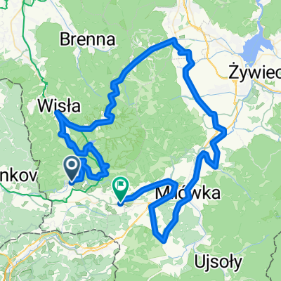
Beskidy "W poszukiwaniu Zoncolan"
A cycling route starting in Istebna, Silesian Voivodeship, Poland.
Overview
About this route
Czy kolarski Zoncolan lub Gliczarów można znaleźć tylko w Alpach i Tatrach?
- -:--
- Duration
- 110.7 km
- Distance
- 1,830 m
- Ascent
- 1,817 m
- Descent
- ---
- Avg. speed
- ---
- Max. altitude

Route quality
Waytypes & surfaces along the route
Waytypes
Quiet road
37.5 km
(34 %)
Road
33.3 km
(30 %)
Surfaces
Paved
87.9 km
(79 %)
Unpaved
1.1 km
(<1 %)
Asphalt
85.4 km
(77 %)
Paved (undefined)
2 km
(2 %)
Route highlights
Points of interest along the route

Point of interest after 78.2 km
przerwa na czaj/kawe + małe co nie co jak mawia Kubuś
Continue with Bikemap
Use, edit, or download this cycling route
You would like to ride Beskidy "W poszukiwaniu Zoncolan" or customize it for your own trip? Here is what you can do with this Bikemap route:
Free features
- Save this route as favorite or in collections
- Copy & plan your own version of this route
- Split it into stages to create a multi-day tour
- Sync your route with Garmin or Wahoo
Premium features
Free trial for 3 days, or one-time payment. More about Bikemap Premium.
- Navigate this route on iOS & Android
- Export a GPX / KML file of this route
- Create your custom printout (try it for free)
- Download this route for offline navigation
Discover more Premium features.
Get Bikemap PremiumFrom our community
Other popular routes starting in Istebna
 7VII`13 VELKY POLOM + KAMESZNICA/Szare/Zameczek/Milosova
- Distance
- 106.6 km
- Ascent
- 1,615 m
- Descent
- 1,625 m
- Location
- Istebna, Silesian Voivodeship, Poland
 Beskidy "W poszukiwaniu Zoncolan"
- Distance
- 110.7 km
- Ascent
- 1,830 m
- Descent
- 1,817 m
- Location
- Istebna, Silesian Voivodeship, Poland
 WTR Wisła - Oświęcim
- Distance
- 98.9 km
- Ascent
- 53 m
- Descent
- 366 m
- Location
- Istebna, Silesian Voivodeship, Poland
 Salmopol Barania
- Distance
- 40.8 km
- Ascent
- 1,109 m
- Descent
- 1,108 m
- Location
- Istebna, Silesian Voivodeship, Poland
 Kubalonka
- Distance
- 21.6 km
- Ascent
- 618 m
- Descent
- 618 m
- Location
- Istebna, Silesian Voivodeship, Poland
 Planowana wisłostrada
- Distance
- 598.8 km
- Ascent
- 758 m
- Descent
- 963 m
- Location
- Istebna, Silesian Voivodeship, Poland
 petla beskidzka 2011
- Distance
- 103.8 km
- Ascent
- 1,750 m
- Descent
- 1,467 m
- Location
- Istebna, Silesian Voivodeship, Poland
 ride through Andziołówka
- Distance
- 19.3 km
- Ascent
- 386 m
- Descent
- 386 m
- Location
- Istebna, Silesian Voivodeship, Poland
Open it in the app