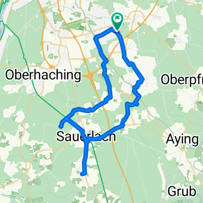
Walchensee über Sylvestern Stausee
A cycling route starting in Hohenbrunn, Bavaria, Germany.
Overview
About this route
Karte entsteht aus zwei zusammengelegten Karten (einmal Muenchen-Bad Toelz, einmal Bad Toelz-Mittenwald).
Route nimmt an, dass man mit dem Zug nach Hause faehrt. Noch nie gefahren, also keine Gewaehr. (cloned from route 939204)- -:--
- Duration
- 129.9 km
- Distance
- 581 m
- Ascent
- 333 m
- Descent
- ---
- Avg. speed
- ---
- Max. altitude
Route quality
Waytypes & surfaces along the route
Waytypes
Busy road
86.7 km
(67 %)
Road
21.3 km
(16 %)
Surfaces
Paved
127.5 km
(98 %)
Unpaved
0.8 km
(<1 %)
Asphalt
126.1 km
(97 %)
Paving stones
1 km
(<1 %)
Continue with Bikemap
Use, edit, or download this cycling route
You would like to ride Walchensee über Sylvestern Stausee or customize it for your own trip? Here is what you can do with this Bikemap route:
Free features
- Save this route as favorite or in collections
- Copy & plan your own version of this route
- Split it into stages to create a multi-day tour
- Sync your route with Garmin or Wahoo
Premium features
Free trial for 3 days, or one-time payment. More about Bikemap Premium.
- Navigate this route on iOS & Android
- Export a GPX / KML file of this route
- Create your custom printout (try it for free)
- Download this route for offline navigation
Discover more Premium features.
Get Bikemap PremiumFrom our community
Other popular routes starting in Hohenbrunn
- Jakobsweg von Ottobrunn - Lindau/Bodensee (D)
- Distance
- 264.7 km
- Ascent
- 2,336 m
- Descent
- 2,200 m
- Location
- Hohenbrunn, Bavaria, Germany
- MTB_Hoh-Ro
- Distance
- 51.2 km
- Ascent
- 101 m
- Descent
- 216 m
- Location
- Hohenbrunn, Bavaria, Germany
- Hohenbrunn to GrasserStrasse
- Distance
- 21.9 km
- Ascent
- 17 m
- Descent
- 66 m
- Location
- Hohenbrunn, Bavaria, Germany
- Moderate Route in Hohenbrunn
- Distance
- 10.8 km
- Ascent
- 604 m
- Descent
- 553 m
- Location
- Hohenbrunn, Bavaria, Germany
- CaffeeMomm
- Distance
- 22.9 km
- Ascent
- 103 m
- Descent
- 106 m
- Location
- Hohenbrunn, Bavaria, Germany
- Aying und zurück
- Distance
- 27.3 km
- Ascent
- 193 m
- Descent
- 202 m
- Location
- Hohenbrunn, Bavaria, Germany
- Munich (suburbs) to Gmund at Tegernsee
- Distance
- 40.3 km
- Ascent
- 265 m
- Descent
- 95 m
- Location
- Hohenbrunn, Bavaria, Germany
- Walchensee über Sylvestern Stausee
- Distance
- 129.9 km
- Ascent
- 581 m
- Descent
- 333 m
- Location
- Hohenbrunn, Bavaria, Germany
Open it in the app