

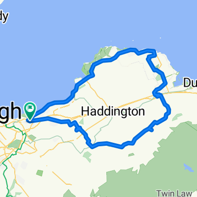
Fisherrow to Tyningham
A cycling route starting in Musselburgh, Scotland, United Kingdom.
Overview
About this route
Motly road with some gravel paths
- -:--
- Duration
- 94.5 km
- Distance
- 383 m
- Ascent
- 383 m
- Descent
- ---
- Avg. speed
- ---
- Max. altitude
Route quality
Waytypes & surfaces along the route
Waytypes
Road
35 km
(37 %)
Cycleway
18.9 km
(20 %)
Surfaces
Paved
56.7 km
(60 %)
Unpaved
14.2 km
(15 %)
Asphalt
56.7 km
(60 %)
Gravel
12.3 km
(13 %)
Continue with Bikemap
Use, edit, or download this cycling route
You would like to ride Fisherrow to Tyningham or customize it for your own trip? Here is what you can do with this Bikemap route:
Free features
- Save this route as favorite or in collections
- Copy & plan your own version of this route
- Split it into stages to create a multi-day tour
- Sync your route with Garmin or Wahoo
Premium features
Free trial for 3 days, or one-time payment. More about Bikemap Premium.
- Navigate this route on iOS & Android
- Export a GPX / KML file of this route
- Create your custom printout (try it for free)
- Download this route for offline navigation
Discover more Premium features.
Get Bikemap PremiumFrom our community
Other popular routes starting in Musselburgh
 Delta Road 1E to Pinkie Road 172
- Distance
- 83.9 km
- Ascent
- 672 m
- Descent
- 677 m
- Location
- Musselburgh, Scotland, United Kingdom
 Gifford Belles April 2018
- Distance
- 63.6 km
- Ascent
- 388 m
- Descent
- 388 m
- Location
- Musselburgh, Scotland, United Kingdom
 Fisherow Bolton Musselburgh 301111
- Distance
- 67.4 km
- Ascent
- 456 m
- Descent
- 454 m
- Location
- Musselburgh, Scotland, United Kingdom
 north berwick 2nd lap
- Distance
- 67 km
- Ascent
- 163 m
- Descent
- 162 m
- Location
- Musselburgh, Scotland, United Kingdom
 Shavelin Drive, Musselburgh to Shavelin Drive, Musselburgh
- Distance
- 30.9 km
- Ascent
- 79 m
- Descent
- 46 m
- Location
- Musselburgh, Scotland, United Kingdom
 carberry and tranent
- Distance
- 20.5 km
- Ascent
- 163 m
- Descent
- 163 m
- Location
- Musselburgh, Scotland, United Kingdom
 This one
- Distance
- 156.7 km
- Ascent
- 1,033 m
- Descent
- 1,034 m
- Location
- Musselburgh, Scotland, United Kingdom
 Fisherrow to Tyningham
- Distance
- 94.5 km
- Ascent
- 383 m
- Descent
- 383 m
- Location
- Musselburgh, Scotland, United Kingdom
Open it in the app