
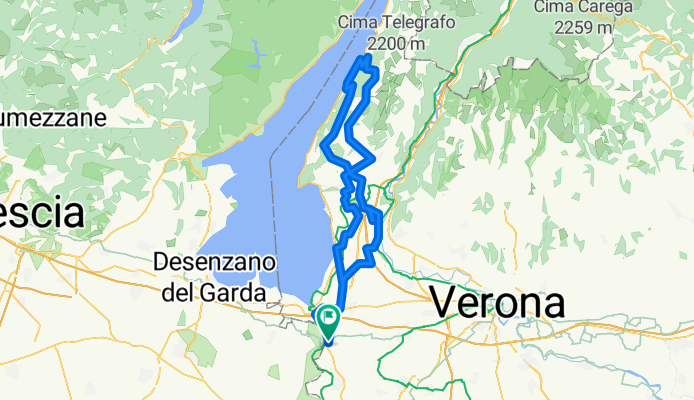
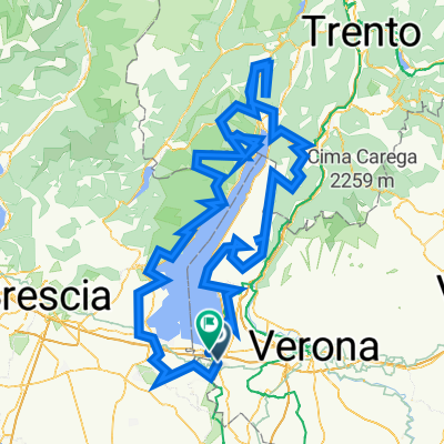
114 km
A cycling route starting in Salionze, Veneto, Italy.
Overview
About this route
- -:--
- Duration
- 114.6 km
- Distance
- 1,782 m
- Ascent
- 1,782 m
- Descent
- ---
- Avg. speed
- ---
- Max. altitude

Continue with Bikemap
Use, edit, or download this cycling route
You would like to ride 114 km or customize it for your own trip? Here is what you can do with this Bikemap route:
Free features
- Save this route as favorite or in collections
- Copy & plan your own version of this route
- Split it into stages to create a multi-day tour
- Sync your route with Garmin or Wahoo
Premium features
Free trial for 3 days, or one-time payment. More about Bikemap Premium.
- Navigate this route on iOS & Android
- Export a GPX / KML file of this route
- Create your custom printout (try it for free)
- Download this route for offline navigation
Discover more Premium features.
Get Bikemap PremiumFrom our community
Other popular routes starting in Salionze
 Hotel Agli Ulivi über Sommacampagna nach Verona BI12
- Distance
- 24.4 km
- Ascent
- 110 m
- Descent
- 180 m
- Location
- Salionze, Veneto, Italy
 Eenzware ronde
- Distance
- 152.2 km
- Ascent
- 1,366 m
- Descent
- 1,361 m
- Location
- Salionze, Veneto, Italy
 sirmione 33,5 km
- Distance
- 33.6 km
- Ascent
- 147 m
- Descent
- 140 m
- Location
- Salionze, Veneto, Italy
 Salionze_Olfino_Valeggio
- Distance
- 41.1 km
- Ascent
- 245 m
- Descent
- 245 m
- Location
- Salionze, Veneto, Italy
 Via Zenati, Castelnuovo del Garda nach Riviera Giosuè Carducci, Peschiera del Garda
- Distance
- 7.2 km
- Ascent
- 39 m
- Descent
- 80 m
- Location
- Salionze, Veneto, Italy
 BikeBand - Ciclabile del Mincio
- Distance
- 35.8 km
- Ascent
- 43 m
- Descent
- 89 m
- Location
- Salionze, Veneto, Italy
 Ciclovia Mantova-Peschiera, Ponti sul Mincio do Via Campo Sportivo 19, Peschiera del Garda
- Distance
- 476 km
- Ascent
- 20,700 m
- Descent
- 20,693 m
- Location
- Salionze, Veneto, Italy
 Via Zenati, Castelnuovo del Garda nach Via Raffaello Sanzio, Valeggio sul Mincio
- Distance
- 10.6 km
- Ascent
- 21 m
- Descent
- 73 m
- Location
- Salionze, Veneto, Italy
Open it in the app