

enterfe
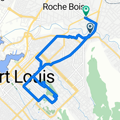
A cycling route starting in Le Hochet, Pamplemousses District, Mauritius.
Overview
About this route
eqfdqerdqew
- -:--
- Duration
- 154.7 km
- Distance
- 1,371 m
- Ascent
- 1,132 m
- Descent
- ---
- Avg. speed
- ---
- Max. altitude

Continue with Bikemap
Use, edit, or download this cycling route
You would like to ride enterfe or customize it for your own trip? Here is what you can do with this Bikemap route:
Free features
- Save this route as favorite or in collections
- Copy & plan your own version of this route
- Split it into stages to create a multi-day tour
- Sync your route with Garmin or Wahoo
Premium features
Free trial for 3 days, or one-time payment. More about Bikemap Premium.
- Navigate this route on iOS & Android
- Export a GPX / KML file of this route
- Create your custom printout (try it for free)
- Download this route for offline navigation
Discover more Premium features.
Get Bikemap PremiumFrom our community
Other popular routes starting in Le Hochet
 enterfe
- Distance
- 154.7 km
- Ascent
- 1,371 m
- Descent
- 1,132 m
- Location
- Le Hochet, Pamplemousses District, Mauritius
 Tour de Maurice 2014 2.Etappe
- Distance
- 112.8 km
- Ascent
- 358 m
- Descent
- 350 m
- Location
- Le Hochet, Pamplemousses District, Mauritius
 Higginson Street, Port Louis to Higginson Street, Port Louis
- Distance
- 7.2 km
- Ascent
- 43 m
- Descent
- 44 m
- Location
- Le Hochet, Pamplemousses District, Mauritius
 Bois Savon Street, Port Louis to WG9Q+WG8, Triolet
- Distance
- 11.5 km
- Ascent
- 39 m
- Descent
- 32 m
- Location
- Le Hochet, Pamplemousses District, Mauritius
 Easy ride
- Distance
- 8.9 km
- Ascent
- 140 m
- Descent
- 144 m
- Location
- Le Hochet, Pamplemousses District, Mauritius
Open it in the app