
Wycieczka Nr 17/2013 – Słobity - 21 lipca
A cycling route starting in Pasłęk, Warmian-Masurian Voivodeship, Poland.
Overview
About this route
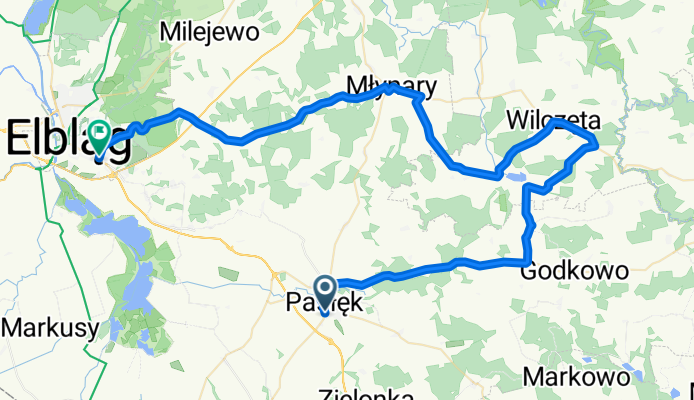
Route: Pasłek, Kopina, Bielica, Burdajny, Osiek, Gładysze, Wilczęta, Karwiny, Słobity, Młynary, Zastawno, Elbląg
- -:--
- Duration
- 67.9 km
- Distance
- 293 m
- Ascent
- 330 m
- Descent
- ---
- Avg. speed
- ---
- Max. altitude

Route quality
Waytypes & surfaces along the route
Waytypes
Road
13.6 km
(20 %)
Quiet road
12.2 km
(18 %)
Surfaces
Paved
48.9 km
(72 %)
Unpaved
7.5 km
(11 %)
Asphalt
41.4 km
(61 %)
Paved (undefined)
7.5 km
(11 %)
Continue with Bikemap
Use, edit, or download this cycling route
You would like to ride Wycieczka Nr 17/2013 – Słobity - 21 lipca or customize it for your own trip? Here is what you can do with this Bikemap route:
Free features
- Save this route as favorite or in collections
- Copy & plan your own version of this route
- Sync your route with Garmin or Wahoo
Premium features
Free trial for 3 days, or one-time payment. More about Bikemap Premium.
- Navigate this route on iOS & Android
- Export a GPX / KML file of this route
- Create your custom printout (try it for free)
- Download this route for offline navigation
Discover more Premium features.
Get Bikemap PremiumFrom our community
Other popular routes starting in Pasłęk
 Pasłęk-Morąg-Małdyty-Wielki Dwór-Lepno-Rydzówka-Pasłęk
- Distance
- 70.3 km
- Ascent
- 268 m
- Descent
- 266 m
- Location
- Pasłęk, Warmian-Masurian Voivodeship, Poland
 Pasłęk-Elbląg-Pasłęk
- Distance
- 46.1 km
- Ascent
- 74 m
- Descent
- 74 m
- Location
- Pasłęk, Warmian-Masurian Voivodeship, Poland
 Kwitajny - Klekotki - czarny
- Distance
- 12.8 km
- Ascent
- 106 m
- Descent
- 110 m
- Location
- Pasłęk, Warmian-Masurian Voivodeship, Poland
 Wycieczka Nr 17/2013 – Słobity - 21 lipca
- Distance
- 67.9 km
- Ascent
- 293 m
- Descent
- 330 m
- Location
- Pasłęk, Warmian-Masurian Voivodeship, Poland
 Wycieczka Nr 8/2010 - Markowo - 30 maja
- Distance
- 73.4 km
- Ascent
- 415 m
- Descent
- 441 m
- Location
- Pasłęk, Warmian-Masurian Voivodeship, Poland
 Trasa Kanałowa
- Distance
- 30.6 km
- Ascent
- 142 m
- Descent
- 142 m
- Location
- Pasłęk, Warmian-Masurian Voivodeship, Poland
 Wkoło Pasłęka
- Distance
- 35.1 km
- Ascent
- 143 m
- Descent
- 143 m
- Location
- Pasłęk, Warmian-Masurian Voivodeship, Poland
 Pasłęk - Braniewo
- Distance
- 54.2 km
- Ascent
- 122 m
- Descent
- 160 m
- Location
- Pasłęk, Warmian-Masurian Voivodeship, Poland
Open it in the app