
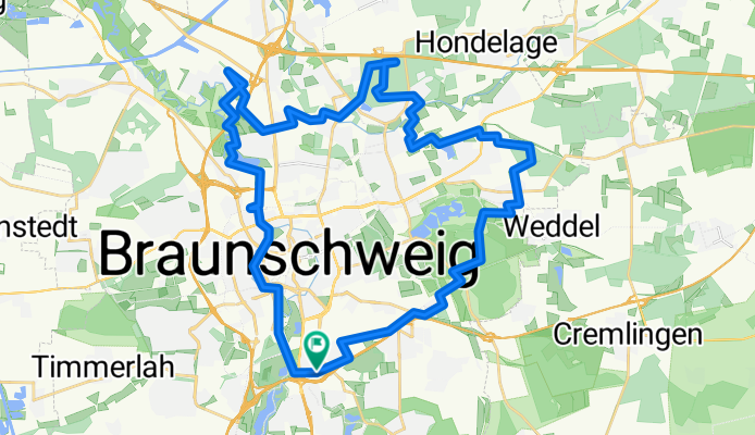
Schapen-Querum-Hansestraße
A cycling route starting in Braunschweig, Lower Saxony, Germany.
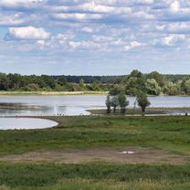
Overview
About this route
MTV Mountainbike group; Tour from 17.07.2013
Short route description:
Route approx. 39km 144Hm highest point approx. 95m above sea level.
Start at the Red Meadow. Via developed bike paths, past the former Federal Railway maintenance facility, it goes to Helmstedter Straße. After a short meadow trail on Elmsburgweg, we ride to Riddagshausen. We pass through Riddagshausen past the Waldforum to Schapen.
Through a narrow field trail we enter the Schapener Forest, which we cross over a 750m trail. Via developed field paths, we head towards Moorhüttensee. Just before a bridge, we turn right onto a path through a reed bed from the lake (partly muddy passage after rainy days). At the end of the path, we turn right before a ford crossing. After crossing a ditch, the route runs parallel to Dibbesdorfer Straße. On the day of the ride, a narrow singletrail through a field was deliberately destroyed by the farmer with a plug. As an alternative, you can fight your way through the meadow or hit the track again via the Schuntertal and Drömlingweg roads. You cross the Schunter via a narrow bridge and after about 1km enter the Querumer Forest. There, we face technical challenges. At kilometer 18.7, we cross a steep stair passage onto the main road to the airfield and then up another staircase (downhill section passable for the brave; uphill possibly doable for experts). After that, we follow a narrow forest path to the former Hussar barracks and shortly after turn back into the forest. At kilometer 19.6 comes one of the most beautiful trails in the Querumer Forest about 750m long; with four drivable tree obstacles (chainring hits) and a tree breakthrough. The route then continues along narrow forest paths through Kralenriede and the Schunterniederung at the Schuntersiedlung (partly muddy passages after flooding). After a short asphalt section, we cross Gifhorner Straße and continue on bike paths past Schwarzenberg towards Pfälzerstraße. We cross the A391 and turn right at the substation onto a meadow trail parallel to the tangent. At kilometer 26.7, a new challenge arises on this route; after a steep ramp, we ride along a narrow path along the mountain ridge, parallel to Hansestraße (view of Porta, Ikea); now fully ridable after logging work. After a steep downhill section, we head towards Veltenhof. There we follow a trail approximately 1.8km long along the Oker, partly along the steep bank, with slight tree obstacles; now fully ridable. At the railway line, a short downhill stair section. Then we go past ÖLpersee and parallel to Oker towards Bammelsburgerteich. We ride over the embankment to the VW Hall and the Spielmannsteiche back to the starting point Red Meadow.
Have fun riding the city-close trails.
Martin
- -:--
- Duration
- 38.9 km
- Distance
- 101 m
- Ascent
- 101 m
- Descent
- ---
- Avg. speed
- ---
- Max. altitude

Route quality
Waytypes & surfaces along the route
Waytypes
Path
17.9 km
(46 %)
Track
10.5 km
(27 %)
Surfaces
Paved
12.4 km
(32 %)
Unpaved
21.4 km
(55 %)
Asphalt
12 km
(31 %)
Gravel
8.2 km
(21 %)
Route highlights
Points of interest along the route
Point of interest after 4.7 km
kurzer Wiesentrail ca. 240m
Point of interest after 10.8 km
schöner Trail mit kurvigen Verlauf und mehrern Grabendurchfahrten im Bergabteil, ca. 750m lang
Point of interest after 14.5 km
kurzer Schilfpfad an den Teichausläufern vom Moorhüttensee, bei Hochwasser schlammige Passage
Point of interest after 14.7 km
bei Hochwasser kleine befahrbare Bachfurt
Point of interest after 14.8 km
Grabendurchfahrt, vorab Wiesentrail
Point of interest after 15.3 km
Trail am 17.7.2013 nicht befahrtbar, da ein Landwirt den Pfad mutwillig mit dem Pflug zerstört hat
Point of interest after 19.3 km
Pferdetrail ca. 400m lang
Point of interest after 20.2 km
steile Treppenpassage bergab
Point of interest after 20.2 km
Treppenauffahrt, wahrscheinlich nur von Profis zu bezwingen
Point of interest after 20.7 km
ca. 700m langer Singletrail mit vier überfahrbaren Baumhindernissen
Point of interest after 23.1 km
Wiesensingletrail an der Schunter entlang, bei Hochwasser oft nicht zu befahren
Point of interest after 24.1 km
enger Singletrail an der Vorwerksiedlung, mit z.T. engen Bewuchs
Point of interest after 26.4 km
Wiesentrail durch hohes Gras parallel zur A391
Point of interest after 27.5 km
kurze Auffahrtrampe auf den Hansestraßewall, ca. 23%
Point of interest after 28 km
Abfahrtrampe ca. 30%
Point of interest after 28.7 km
ca. 700m langer Singletrail am Okersteilufer entlang, jetzt durchgehend befahrbar
Point of interest after 30.1 km
kurze Treppenabfahrt unter der Eisenbahnlinie
Point of interest after 30.6 km
kurzer Singletrail zum Ölpersee ca. 470m lang
Point of interest after 33 km
wegen Baustelle am 17.7.2013 nicht befahrbar
Continue with Bikemap
Use, edit, or download this cycling route
You would like to ride Schapen-Querum-Hansestraße or customize it for your own trip? Here is what you can do with this Bikemap route:
Free features
- Save this route as favorite or in collections
- Copy & plan your own version of this route
- Sync your route with Garmin or Wahoo
Premium features
Free trial for 3 days, or one-time payment. More about Bikemap Premium.
- Navigate this route on iOS & Android
- Export a GPX / KML file of this route
- Create your custom printout (try it for free)
- Download this route for offline navigation
Discover more Premium features.
Get Bikemap PremiumFrom our community
Other popular routes starting in Braunschweig
 Kurze Tour über Tetzelstein und Rieseberg
- Distance
- 61.8 km
- Ascent
- 370 m
- Descent
- 364 m
- Location
- Braunschweig, Lower Saxony, Germany
 NaturTour
- Distance
- 26 km
- Ascent
- 130 m
- Descent
- 121 m
- Location
- Braunschweig, Lower Saxony, Germany
 4-Seen-Runde
- Distance
- 33.8 km
- Ascent
- 71 m
- Descent
- 71 m
- Location
- Braunschweig, Lower Saxony, Germany
 Entdecke BS Nord
- Distance
- 31.8 km
- Ascent
- 49 m
- Descent
- 49 m
- Location
- Braunschweig, Lower Saxony, Germany
 Rund um den Elm
- Distance
- 61.3 km
- Ascent
- 366 m
- Descent
- 333 m
- Location
- Braunschweig, Lower Saxony, Germany
 Südsee mit Okerauen
- Distance
- 19.4 km
- Ascent
- 27 m
- Descent
- 29 m
- Location
- Braunschweig, Lower Saxony, Germany
 Tankumsee
- Distance
- 61.6 km
- Ascent
- 190 m
- Descent
- 192 m
- Location
- Braunschweig, Lower Saxony, Germany
 Elm Bergtour
- Distance
- 68.5 km
- Ascent
- 487 m
- Descent
- 487 m
- Location
- Braunschweig, Lower Saxony, Germany
Open it in the app