

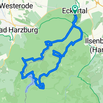
Harz: Eckertal - Osterwieck - Eckertal
A cycling route starting in Stapelburg, Saxony-Anhalt, Germany.
Overview
About this route
A round to the cherry trees in Vorharz.
- -:--
- Duration
- 40.1 km
- Distance
- 196 m
- Ascent
- 196 m
- Descent
- ---
- Avg. speed
- ---
- Max. altitude
Route quality
Waytypes & surfaces along the route
Waytypes
Track
14.4 km
(36 %)
Quiet road
12 km
(30 %)
Surfaces
Paved
22 km
(55 %)
Unpaved
7.2 km
(18 %)
Asphalt
14 km
(35 %)
Concrete
5.6 km
(14 %)
Continue with Bikemap
Use, edit, or download this cycling route
You would like to ride Harz: Eckertal - Osterwieck - Eckertal or customize it for your own trip? Here is what you can do with this Bikemap route:
Free features
- Save this route as favorite or in collections
- Copy & plan your own version of this route
- Sync your route with Garmin or Wahoo
Premium features
Free trial for 3 days, or one-time payment. More about Bikemap Premium.
- Navigate this route on iOS & Android
- Export a GPX / KML file of this route
- Create your custom printout (try it for free)
- Download this route for offline navigation
Discover more Premium features.
Get Bikemap PremiumFrom our community
Other popular routes starting in Stapelburg
 Ecker
Ecker- Distance
- 31.9 km
- Ascent
- 621 m
- Descent
- 623 m
- Location
- Stapelburg, Saxony-Anhalt, Germany
 Brockenaufstieg
- Distance
- 18.2 km
- Ascent
- 997 m
- Descent
- 120 m
- Location
- Stapelburg, Saxony-Anhalt, Germany
 D11: Stapelburg - Mariental
- Distance
- 70.4 km
- Ascent
- 476 m
- Descent
- 601 m
- Location
- Stapelburg, Saxony-Anhalt, Germany
 Harz: Eckertal - Osterwieck - Eckertal
- Distance
- 40.1 km
- Ascent
- 196 m
- Descent
- 196 m
- Location
- Stapelburg, Saxony-Anhalt, Germany
 Kurze Harztour
- Distance
- 32.5 km
- Ascent
- 659 m
- Descent
- 650 m
- Location
- Stapelburg, Saxony-Anhalt, Germany
 Harzrunde
- Distance
- 49.3 km
- Ascent
- 903 m
- Descent
- 903 m
- Location
- Stapelburg, Saxony-Anhalt, Germany
 GRX 81 680 Ecker Oesig Strade
- Distance
- 81.2 km
- Ascent
- 442 m
- Descent
- 446 m
- Location
- Stapelburg, Saxony-Anhalt, Germany
 1000 Höhenmeter am Stück "Brockentour"
- Distance
- 36.9 km
- Ascent
- 1,047 m
- Descent
- 1,050 m
- Location
- Stapelburg, Saxony-Anhalt, Germany
Open it in the app