

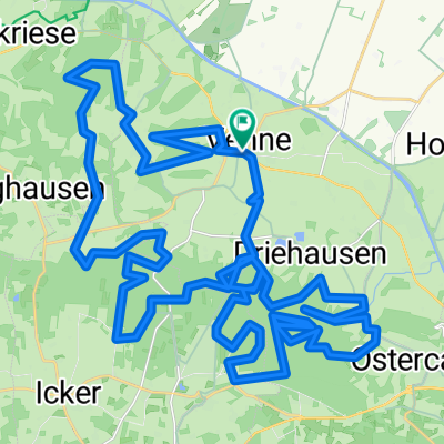
Samstagmittagtour
A cycling route starting in Ostercappeln, Lower Saxony, Germany.
Overview
About this route
Comfortable outing tour, also suitable for children, with many places to stop along the way
- -:--
- Duration
- 50.9 km
- Distance
- 156 m
- Ascent
- 156 m
- Descent
- ---
- Avg. speed
- ---
- Max. altitude
Route quality
Waytypes & surfaces along the route
Waytypes
Quiet road
33.6 km
(66 %)
Path
7.1 km
(14 %)
Surfaces
Paved
30 km
(59 %)
Unpaved
0.5 km
(1 %)
Asphalt
22.9 km
(45 %)
Paved (undefined)
6.1 km
(12 %)
Continue with Bikemap
Use, edit, or download this cycling route
You would like to ride Samstagmittagtour or customize it for your own trip? Here is what you can do with this Bikemap route:
Free features
- Save this route as favorite or in collections
- Copy & plan your own version of this route
- Sync your route with Garmin or Wahoo
Premium features
Free trial for 3 days, or one-time payment. More about Bikemap Premium.
- Navigate this route on iOS & Android
- Export a GPX / KML file of this route
- Create your custom printout (try it for free)
- Download this route for offline navigation
Discover more Premium features.
Get Bikemap PremiumFrom our community
Other popular routes starting in Ostercappeln
 CE140311
- Distance
- 51.1 km
- Ascent
- 64 m
- Descent
- 64 m
- Location
- Ostercappeln, Lower Saxony, Germany
 Von Kalkriese nach Bad Essen
- Distance
- 19.9 km
- Ascent
- 25 m
- Descent
- 23 m
- Location
- Ostercappeln, Lower Saxony, Germany
 Schloss Hünnefeld - Venne: 41km
- Distance
- 37.9 km
- Ascent
- 60 m
- Descent
- 62 m
- Location
- Ostercappeln, Lower Saxony, Germany
 Maitour 08.05.2011
- Distance
- 53.5 km
- Ascent
- 169 m
- Descent
- 169 m
- Location
- Ostercappeln, Lower Saxony, Germany
 Wiehencross 2011
- Distance
- 47.2 km
- Ascent
- 646 m
- Descent
- 645 m
- Location
- Ostercappeln, Lower Saxony, Germany
 Venner Cross CLONED FROM ROUTE 183805
- Distance
- 51.6 km
- Ascent
- 719 m
- Descent
- 719 m
- Location
- Ostercappeln, Lower Saxony, Germany
 Terkhorns Garten, Ostercappeln nach Hauptstraße, Ostercappeln
- Distance
- 50.7 km
- Ascent
- 356 m
- Descent
- 351 m
- Location
- Ostercappeln, Lower Saxony, Germany
 zeitfahrstrecke
- Distance
- 4.7 km
- Ascent
- 55 m
- Descent
- 9 m
- Location
- Ostercappeln, Lower Saxony, Germany
Open it in the app