

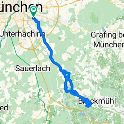
Rundkurs Trudering - Tierpark - Grünwald - Trudering
A cycling route starting in Neubiberg, Bavaria, Germany.
Overview
About this route
Start and finish at the intersection of Augustiner- and Eigerstraße. Then head towards the city center through green spaces to the Isar at Maximiliananlagen. From now to Grünwald, always along the Isar (Isar-Radlweg). At the Grünwalder bridge, the Brückenwirt beer garden offers a good half-time stop. (cloned from route 14855)
- -:--
- Duration
- 36.7 km
- Distance
- 81 m
- Ascent
- 79 m
- Descent
- ---
- Avg. speed
- ---
- Max. altitude
Route quality
Waytypes & surfaces along the route
Waytypes
Quiet road
9.9 km
(27 %)
Path
8.8 km
(24 %)
Surfaces
Paved
27.9 km
(76 %)
Unpaved
5.1 km
(14 %)
Asphalt
26.1 km
(71 %)
Gravel
2.6 km
(7 %)
Route highlights
Points of interest along the route
Point of interest after 0 km
Start und Ziel. Gesamtstrecke ca. 39 km.
Point of interest after 7.4 km
der Radlweg geht immer unter den Strassen durch, d.h. ab hier muss man nicht mehr auf der Strasse fahren und zwar bis nach Grünwald.
Point of interest after 13.9 km
... wer jetzt schon eine kleine Stärkung braucht, findet hier was Feines ...
Point of interest after 15 km
... an dem Kiosk kann man einen kurzen Stopp einlegen und z.B. eine Radler-Halbe geniessen.
Point of interest after 19.2 km
Halbzeit (etwas mehr) Zeit beim Brückenwirt eine Rast einzulegen.
Point of interest after 35.2 km
Unterführung nützen.
Continue with Bikemap
Use, edit, or download this cycling route
You would like to ride Rundkurs Trudering - Tierpark - Grünwald - Trudering or customize it for your own trip? Here is what you can do with this Bikemap route:
Free features
- Save this route as favorite or in collections
- Copy & plan your own version of this route
- Sync your route with Garmin or Wahoo
Premium features
Free trial for 3 days, or one-time payment. More about Bikemap Premium.
- Navigate this route on iOS & Android
- Export a GPX / KML file of this route
- Create your custom printout (try it for free)
- Download this route for offline navigation
Discover more Premium features.
Get Bikemap PremiumFrom our community
Other popular routes starting in Neubiberg
 Route entlang der Isar und des Perlacher Forstes
- Distance
- 25.1 km
- Ascent
- 126 m
- Descent
- 126 m
- Location
- Neubiberg, Bavaria, Germany
 Neubiberg-Leitzachtal-Irschenberg
- Distance
- 126.6 km
- Ascent
- 1,375 m
- Descent
- 1,372 m
- Location
- Neubiberg, Bavaria, Germany
 Isarrunde
- Distance
- 39.5 km
- Ascent
- 303 m
- Descent
- 303 m
- Location
- Neubiberg, Bavaria, Germany
 Kirchsee Tour
- Distance
- 95.8 km
- Ascent
- 585 m
- Descent
- 547 m
- Location
- Neubiberg, Bavaria, Germany
 Trudering - Vagen (Mangfalltal) und zurück
- Distance
- 78.7 km
- Ascent
- 506 m
- Descent
- 469 m
- Location
- Neubiberg, Bavaria, Germany
 Glonn
Glonn- Distance
- 49.1 km
- Ascent
- 551 m
- Descent
- 553 m
- Location
- Neubiberg, Bavaria, Germany
 Perlach - Kloster Andechs
- Distance
- 47.6 km
- Ascent
- 328 m
- Descent
- 187 m
- Location
- Neubiberg, Bavaria, Germany
 THE WALTHERS Waldperlach - Isar Runde 01
- Distance
- 34.7 km
- Ascent
- 72 m
- Descent
- 73 m
- Location
- Neubiberg, Bavaria, Germany
Open it in the app