

De Vael Ouwe 2013
A cycling route starting in Dieren, Gelderland, The Netherlands.
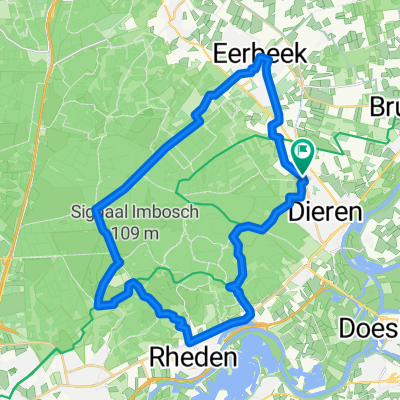
Overview
About this route
Route via Park Hoge Veluwe Nat. Park de Veluwezoom Postbank
- -:--
- Duration
- 103.5 km
- Distance
- 294 m
- Ascent
- 293 m
- Descent
- ---
- Avg. speed
- ---
- Max. altitude
Route quality
Waytypes & surfaces along the route
Waytypes
Cycleway
43.5 km
(42 %)
Quiet road
42.4 km
(41 %)
Surfaces
Paved
88 km
(85 %)
Asphalt
82.8 km
(80 %)
Concrete
5.2 km
(5 %)
Undefined
15.5 km
(15 %)
Continue with Bikemap
Use, edit, or download this cycling route
You would like to ride De Vael Ouwe 2013 or customize it for your own trip? Here is what you can do with this Bikemap route:
Free features
- Save this route as favorite or in collections
- Copy & plan your own version of this route
- Split it into stages to create a multi-day tour
- Sync your route with Garmin or Wahoo
Premium features
Free trial for 3 days, or one-time payment. More about Bikemap Premium.
- Navigate this route on iOS & Android
- Export a GPX / KML file of this route
- Create your custom printout (try it for free)
- Download this route for offline navigation
Discover more Premium features.
Get Bikemap PremiumFrom our community
Other popular routes starting in Dieren
 nl-ge021 doesburg-oude-ijssel-doetinchem
- Distance
- 63.8 km
- Ascent
- 24 m
- Descent
- 25 m
- Location
- Dieren, Gelderland, The Netherlands
 Relaxed route in Dieren
- Distance
- 12 km
- Ascent
- 93 m
- Descent
- 101 m
- Location
- Dieren, Gelderland, The Netherlands
 2020 06 23 Rondje Veluwezoom (gedeeltelijk) vanuit Rheden (Route.nl 135078)
- Distance
- 34.9 km
- Ascent
- 198 m
- Descent
- 198 m
- Location
- Dieren, Gelderland, The Netherlands
 Terug naar toen
- Distance
- 27.7 km
- Ascent
- 60 m
- Descent
- 57 m
- Location
- Dieren, Gelderland, The Netherlands
 Priesnitzlaan 4, Laag-Soeren do Badhuiskade 3, Amsterdam
- Distance
- 105.3 km
- Ascent
- 238 m
- Descent
- 258 m
- Location
- Dieren, Gelderland, The Netherlands
 Priesnitzlaan 4, Laag-Soeren do Nieuwe Spiegelstraat 5, Amsterdam
- Distance
- 107.8 km
- Ascent
- 890 m
- Descent
- 955 m
- Location
- Dieren, Gelderland, The Netherlands
 De Vael Ouwe 2013
- Distance
- 103.5 km
- Ascent
- 294 m
- Descent
- 293 m
- Location
- Dieren, Gelderland, The Netherlands
 RN Dag 2
- Distance
- 57.1 km
- Ascent
- 62 m
- Descent
- 63 m
- Location
- Dieren, Gelderland, The Netherlands
Open it in the app