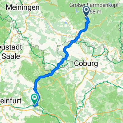
Masserberg/Königsetappe FP 09.2013
A cycling route starting in Masserberg, Free State of Thuringia, Germany.
Overview
About this route
Thüringerwald-Frankenwald-Runde mit rd. 2.500 Höhenmetern
- -:--
- Duration
- 160.3 km
- Distance
- 1,694 m
- Ascent
- 1,691 m
- Descent
- ---
- Avg. speed
- ---
- Avg. speed
Route quality
Waytypes & surfaces along the route
Waytypes
Busy road
114.1 km
(71 %)
Road
23.2 km
(14 %)
Surfaces
Paved
68.1 km
(42 %)
Unpaved
2.4 km
(1 %)
Asphalt
67.7 km
(42 %)
Unpaved (undefined)
1.1 km
(<1 %)
Continue with Bikemap
Use, edit, or download this cycling route
You would like to ride Masserberg/Königsetappe FP 09.2013 or customize it for your own trip? Here is what you can do with this Bikemap route:
Free features
- Save this route as favorite or in collections
- Copy & plan your own version of this route
- Sync your route with Garmin or Wahoo
Premium features
Free trial for 3 days, or one-time payment. More about Bikemap Premium.
- Navigate this route on iOS & Android
- Export a GPX / KML file of this route
- Create your custom printout (try it for free)
- Download this route for offline navigation
Discover more Premium features.
Get Bikemap PremiumFrom our community
Other popular routes starting in Masserberg
- Werraradweg
- Distance
- 332.8 km
- Ascent
- 587 m
- Descent
- 1,236 m
- Location
- Masserberg, Free State of Thuringia, Germany
- Talsperre Schönbrunn
- Distance
- 43.6 km
- Ascent
- 1,031 m
- Descent
- 1,031 m
- Location
- Masserberg, Free State of Thuringia, Germany
- Werratal-Radweg
- Distance
- 322.9 km
- Ascent
- 477 m
- Descent
- 1,082 m
- Location
- Masserberg, Free State of Thuringia, Germany
- Werratalradweg-1
- Distance
- 283.4 km
- Ascent
- 209 m
- Descent
- 835 m
- Location
- Masserberg, Free State of Thuringia, Germany
- Werratal-Radweg
- Distance
- 278.6 km
- Ascent
- 145 m
- Descent
- 798 m
- Location
- Masserberg, Free State of Thuringia, Germany
- 2025-05-08_Masserberg-Werra-Meiningen
- Distance
- 71.5 km
- Ascent
- 511 m
- Descent
- 1,001 m
- Location
- Masserberg, Free State of Thuringia, Germany
- RennsteigFeierabendrunde CLONED FROM ROUTE 187129
- Distance
- 33.6 km
- Ascent
- 476 m
- Descent
- 476 m
- Location
- Masserberg, Free State of Thuringia, Germany
- Skoda aktiv Intensiv 13.09.2009 JE_HR
- Distance
- 86.4 km
- Ascent
- 804 m
- Descent
- 1,125 m
- Location
- Masserberg, Free State of Thuringia, Germany
Open it in the app