

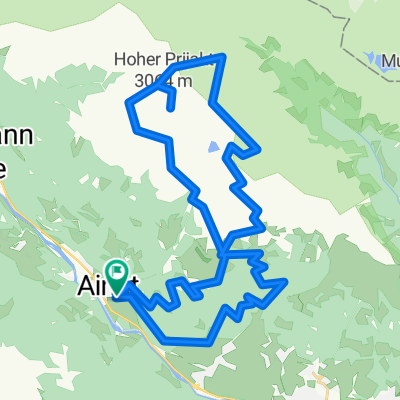
Schlaitener Tor Moschumandl
A cycling route starting in Ainet, Tyrol, Austria.
Overview
About this route
Moscow
- -:--
- Duration
- 14.4 km
- Distance
- 1,441 m
- Ascent
- 41 m
- Descent
- ---
- Avg. speed
- ---
- Max. altitude

Continue with Bikemap
Use, edit, or download this cycling route
You would like to ride Schlaitener Tor Moschumandl or customize it for your own trip? Here is what you can do with this Bikemap route:
Free features
- Save this route as favorite or in collections
- Copy & plan your own version of this route
- Sync your route with Garmin or Wahoo
Premium features
Free trial for 3 days, or one-time payment. More about Bikemap Premium.
- Navigate this route on iOS & Android
- Export a GPX / KML file of this route
- Create your custom printout (try it for free)
- Download this route for offline navigation
Discover more Premium features.
Get Bikemap PremiumFrom our community
Other popular routes starting in Ainet
 Schlaitener Tor Moschumandl
- Distance
- 14.4 km
- Ascent
- 1,441 m
- Descent
- 41 m
- Location
- Ainet, Tyrol, Austria
 bergfahrt jenny österreich
- Distance
- 29.8 km
- Ascent
- 678 m
- Descent
- 169 m
- Location
- Ainet, Tyrol, Austria
 Ainet 108b - Ainet 108b
- Distance
- 42.7 km
- Ascent
- 393 m
- Descent
- 401 m
- Location
- Ainet, Tyrol, Austria
 San Candido - Ainet Austria
- Distance
- 57.9 km
- Ascent
- 567 m
- Descent
- 62 m
- Location
- Ainet, Tyrol, Austria
 Drau 01 Ainet - Sachsenburg
- Distance
- 71.6 km
- Ascent
- 138 m
- Descent
- 272 m
- Location
- Ainet, Tyrol, Austria
 MTB_5000
- Distance
- 45.9 km
- Ascent
- 3,855 m
- Descent
- 3,854 m
- Location
- Ainet, Tyrol, Austria
 2009_08 Lienzer Hütte_Seichenbrunner Alm pěšky
- Distance
- 4.2 km
- Ascent
- 20 m
- Descent
- 297 m
- Location
- Ainet, Tyrol, Austria
 Schlaitener Tor Moschumandl
- Distance
- 14.4 km
- Ascent
- 1,450 m
- Descent
- 50 m
- Location
- Ainet, Tyrol, Austria
Open it in the app