

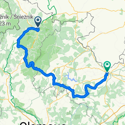
Dlouhé stráně, Praděd
A cycling route starting in Jeseník, Olomoucký kraj, Czechia.
Overview
About this route
Královská etapa Moc těžké
- -:--
- Duration
- 131.6 km
- Distance
- 2,867 m
- Ascent
- 2,873 m
- Descent
- ---
- Avg. speed
- ---
- Max. altitude
Route quality
Waytypes & surfaces along the route
Waytypes
Busy road
68.2 km
(52 %)
Access road
23.4 km
(18 %)
Surfaces
Paved
77.3 km
(59 %)
Asphalt
77 km
(59 %)
Paving stones
0.3 km
(<1 %)
Undefined
54.3 km
(41 %)
Continue with Bikemap
Use, edit, or download this cycling route
You would like to ride Dlouhé stráně, Praděd or customize it for your own trip? Here is what you can do with this Bikemap route:
Free features
- Save this route as favorite or in collections
- Copy & plan your own version of this route
- Split it into stages to create a multi-day tour
- Sync your route with Garmin or Wahoo
Premium features
Free trial for 3 days, or one-time payment. More about Bikemap Premium.
- Navigate this route on iOS & Android
- Export a GPX / KML file of this route
- Create your custom printout (try it for free)
- Download this route for offline navigation
Discover more Premium features.
Get Bikemap PremiumFrom our community
Other popular routes starting in Jeseník
 Jeseník Javorník Bílá V. Kamienica Pczkovw Kalkow Glucholazy Jeseník
- Distance
- 110.6 km
- Ascent
- 475 m
- Descent
- 584 m
- Location
- Jeseník, Olomoucký kraj, Czechia
 Jeseník Vidly Vrbno Karlovice Holčovice Horní údolí Mikulovice Jeseník
- Distance
- 87 km
- Ascent
- 1,230 m
- Descent
- 1,295 m
- Location
- Jeseník, Olomoucký kraj, Czechia
 Cesta svobody
- Distance
- 13.8 km
- Ascent
- 616 m
- Descent
- 36 m
- Location
- Jeseník, Olomoucký kraj, Czechia
 Adolfovice-Obri skaly-Serak-Bela p.Pradadem
- Distance
- 24.2 km
- Ascent
- 915 m
- Descent
- 916 m
- Location
- Jeseník, Olomoucký kraj, Czechia
 Praděd
- Distance
- 100.5 km
- Ascent
- 1,663 m
- Descent
- 1,663 m
- Location
- Jeseník, Olomoucký kraj, Czechia
 Jeseník, Rejvíz, pásmo Orlíka
- Distance
- 60 km
- Ascent
- 828 m
- Descent
- 828 m
- Location
- Jeseník, Olomoucký kraj, Czechia
 Jeseník-Sobotín-Rýmařov-Budišov nad Bud.-Opava
- Distance
- 149.4 km
- Ascent
- 1,554 m
- Descent
- 1,729 m
- Location
- Jeseník, Olomoucký kraj, Czechia
 Kopce Jeseníků: Videlský kříž
- Distance
- 4 km
- Ascent
- 335 m
- Descent
- 55 m
- Location
- Jeseník, Olomoucký kraj, Czechia
Open it in the app