

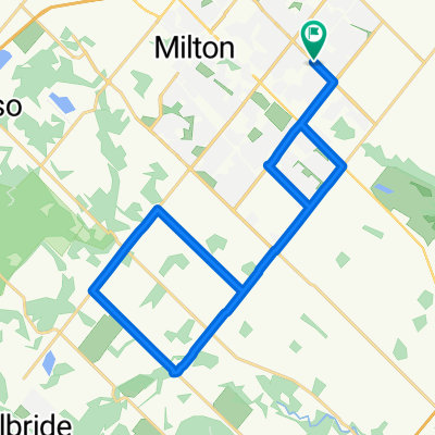
60k Loop.
A cycling route starting in Milton, Ontario, Canada.
Overview
About this route
Acton, Balinafad, Badlands, Cider House, Cheltenham, Terra Cotta, Glen Williams, Limehouse, Acton
60.29km- -:--
- Duration
- 60.4 km
- Distance
- 366 m
- Ascent
- 367 m
- Descent
- ---
- Avg. speed
- ---
- Max. altitude
Route quality
Waytypes & surfaces along the route
Waytypes
Road
34.4 km
(57 %)
Quiet road
3.6 km
(6 %)
Undefined
22.3 km
(37 %)
Surfaces
Paved
50.1 km
(83 %)
Asphalt
40.4 km
(67 %)
Paved (undefined)
9.7 km
(16 %)
Undefined
10.3 km
(17 %)
Route highlights
Points of interest along the route
Point of interest after 31.3 km
Spirit Tree Cider House
Continue with Bikemap
Use, edit, or download this cycling route
You would like to ride 60k Loop. or customize it for your own trip? Here is what you can do with this Bikemap route:
Free features
- Save this route as favorite or in collections
- Copy & plan your own version of this route
- Sync your route with Garmin or Wahoo
Premium features
Free trial for 3 days, or one-time payment. More about Bikemap Premium.
- Navigate this route on iOS & Android
- Export a GPX / KML file of this route
- Create your custom printout (try it for free)
- Download this route for offline navigation
Discover more Premium features.
Get Bikemap PremiumFrom our community
Other popular routes starting in Milton
 Hornby 80K
- Distance
- 75.4 km
- Ascent
- 330 m
- Descent
- 240 m
- Location
- Milton, Ontario, Canada
 May242025-TourDeIsmaili
- Distance
- 54.8 km
- Ascent
- 304 m
- Descent
- 307 m
- Location
- Milton, Ontario, Canada
 26K Start Season - Not much Hill
- Distance
- 27.6 km
- Ascent
- 86 m
- Descent
- 87 m
- Location
- Milton, Ontario, Canada
 Cusick Circle 429, Milton to Cusick Circle 420, Milton
- Distance
- 20 km
- Ascent
- 193 m
- Descent
- 195 m
- Location
- Milton, Ontario, Canada
 Waterdown and back
- Distance
- 72.6 km
- Ascent
- 257 m
- Descent
- 257 m
- Location
- Milton, Ontario, Canada
 HILTON FALLS
- Distance
- 9.4 km
- Ascent
- 48 m
- Descent
- 32 m
- Location
- Milton, Ontario, Canada
 Mountsburg
- Distance
- 49.2 km
- Ascent
- 233 m
- Descent
- 231 m
- Location
- Milton, Ontario, Canada
 Practice Route 03 - 38km
- Distance
- 38 km
- Ascent
- 112 m
- Descent
- 115 m
- Location
- Milton, Ontario, Canada
Open it in the app