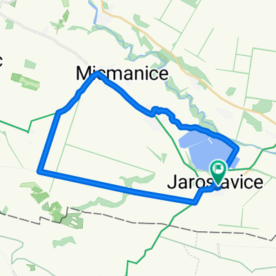
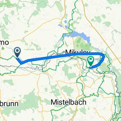
NJKČR - 1. etapa
A cycling route starting in Jaroslavice, South Moravian, Czechia.
Overview
About this route
První etapa z celkových třiceti. Na jednokolce kolem republiky :)
- -:--
- Duration
- 71.7 km
- Distance
- 208 m
- Ascent
- 247 m
- Descent
- ---
- Avg. speed
- ---
- Max. altitude
Route quality
Waytypes & surfaces along the route
Waytypes
Track
27.6 km
(38 %)
Road
19 km
(26 %)
Surfaces
Paved
58.8 km
(82 %)
Unpaved
2.3 km
(3 %)
Asphalt
57.7 km
(81 %)
Gravel
2.3 km
(3 %)
Continue with Bikemap
Use, edit, or download this cycling route
You would like to ride NJKČR - 1. etapa or customize it for your own trip? Here is what you can do with this Bikemap route:
Free features
- Save this route as favorite or in collections
- Copy & plan your own version of this route
- Sync your route with Garmin or Wahoo
Premium features
Free trial for 3 days, or one-time payment. More about Bikemap Premium.
- Navigate this route on iOS & Android
- Export a GPX / KML file of this route
- Create your custom printout (try it for free)
- Download this route for offline navigation
Discover more Premium features.
Get Bikemap PremiumFrom our community
Other popular routes starting in Jaroslavice
- NJKČR - 1. etapa
- Distance
- 71.7 km
- Ascent
- 208 m
- Descent
- 247 m
- Location
- Jaroslavice, South Moravian, Czechia
- 07a-Jaroslavice-ZnojmoCD
- Distance
- 18.8 km
- Ascent
- 162 m
- Descent
- 88 m
- Location
- Jaroslavice, South Moravian, Czechia
- Trénink na Valtické cyklobraní Kooperativy
- Distance
- 53 km
- Ascent
- 286 m
- Descent
- 182 m
- Location
- Jaroslavice, South Moravian, Czechia
- Triko
- Distance
- 141.1 km
- Ascent
- 358 m
- Descent
- 412 m
- Location
- Jaroslavice, South Moravian, Czechia
- Berlin - Prag Etappe 18 Jaroslavice - Vranov nad Dyji
- Distance
- 52.8 km
- Ascent
- 653 m
- Descent
- 521 m
- Location
- Jaroslavice, South Moravian, Czechia
- Jaroslavice-Laa_44_plan
- Distance
- 44.8 km
- Ascent
- 87 m
- Descent
- 87 m
- Location
- Jaroslavice, South Moravian, Czechia
- NP Podyjí, Hardegg, Retz
- Distance
- 113.2 km
- Ascent
- 794 m
- Descent
- 795 m
- Location
- Jaroslavice, South Moravian, Czechia
- Trasa z Slup do Telč
- Distance
- 103.7 km
- Ascent
- 1,516 m
- Descent
- 1,196 m
- Location
- Jaroslavice, South Moravian, Czechia
Open it in the app