

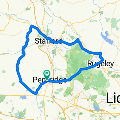
Penkridge to Swynnerton
A cycling route starting in Penkridge, England, United Kingdom.
Overview
About this route
Penkridge to Swynnerton
- -:--
- Duration
- 48.2 km
- Distance
- 221 m
- Ascent
- 170 m
- Descent
- ---
- Avg. speed
- ---
- Max. altitude
Continue with Bikemap
Use, edit, or download this cycling route
You would like to ride Penkridge to Swynnerton or customize it for your own trip? Here is what you can do with this Bikemap route:
Free features
- Save this route as favorite or in collections
- Copy & plan your own version of this route
- Sync your route with Garmin or Wahoo
Premium features
Free trial for 3 days, or one-time payment. More about Bikemap Premium.
- Navigate this route on iOS & Android
- Export a GPX / KML file of this route
- Create your custom printout (try it for free)
- Download this route for offline navigation
Discover more Premium features.
Get Bikemap PremiumFrom our community
Other popular routes starting in Penkridge
 4 Bridge Terrace, Stafford Road, Stafford to 30 Fairway, Stafford
- Distance
- 11.1 km
- Ascent
- 12 m
- Descent
- 22 m
- Location
- Penkridge, England, United Kingdom
 Congreve to Newton 2018
- Distance
- 492.5 km
- Ascent
- 1,031 m
- Descent
- 1,030 m
- Location
- Penkridge, England, United Kingdom
 Whiston Road, Penkridge, Stafford to Woollaston Lane, Penkridge, Stafford
- Distance
- 4.1 km
- Ascent
- 29 m
- Descent
- 26 m
- Location
- Penkridge, England, United Kingdom
 Penkridge - Camp site
- Distance
- 15 km
- Ascent
- 209 m
- Descent
- 107 m
- Location
- Penkridge, England, United Kingdom
 Stafford, Penkridge to Pinfold Lane, Penkridge
- Distance
- 63 km
- Ascent
- 473 m
- Descent
- 473 m
- Location
- Penkridge, England, United Kingdom
 LeJog - Day 6
- Distance
- 77.1 km
- Ascent
- 811 m
- Descent
- 559 m
- Location
- Penkridge, England, United Kingdom
 Wood Bank Lane, Penkridge, Stafford to Whiston Road, Penkridge, Stafford
- Distance
- 2.6 km
- Ascent
- 94 m
- Descent
- 91 m
- Location
- Penkridge, England, United Kingdom
 Last four days of my 2010 JOGLE.
- Distance
- 495.2 km
- Ascent
- 1,085 m
- Descent
- 1,139 m
- Location
- Penkridge, England, United Kingdom
Open it in the app