

Dag 7
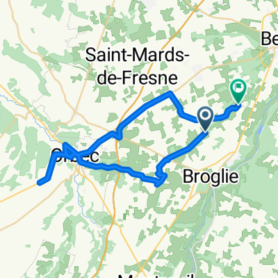
A cycling route starting in Broglie, Normandy, France.
Overview
About this route
Montrueil L'Argille => Souge Le Ganelon
- -:--
- Duration
- 99.2 km
- Distance
- 550 m
- Ascent
- 663 m
- Descent
- ---
- Avg. speed
- ---
- Max. altitude
Route quality
Waytypes & surfaces along the route
Waytypes
Road
45.6 km
(46 %)
Quiet road
37.7 km
(38 %)
Surfaces
Paved
8.9 km
(9 %)
Asphalt
6 km
(6 %)
Paved (undefined)
3 km
(3 %)
Undefined
90.3 km
(91 %)
Continue with Bikemap
Use, edit, or download this cycling route
You would like to ride Dag 7 or customize it for your own trip? Here is what you can do with this Bikemap route:
Free features
- Save this route as favorite or in collections
- Copy & plan your own version of this route
- Split it into stages to create a multi-day tour
- Sync your route with Garmin or Wahoo
Premium features
Free trial for 3 days, or one-time payment. More about Bikemap Premium.
- Navigate this route on iOS & Android
- Export a GPX / KML file of this route
- Create your custom printout (try it for free)
- Download this route for offline navigation
Discover more Premium features.
Get Bikemap PremiumFrom our community
Other popular routes starting in Broglie
 Dag 7
Dag 7- Distance
- 99.2 km
- Ascent
- 550 m
- Descent
- 663 m
- Location
- Broglie, Normandy, France
 Tour de Normandie 02
- Distance
- 18 km
- Ascent
- 94 m
- Descent
- 187 m
- Location
- Broglie, Normandy, France
 De 102 Route des Villequiers, La Trinité-de-Réville à 102 Route des Villequiers, La Trinité-de-Réville
- Distance
- 20.5 km
- Ascent
- 354 m
- Descent
- 352 m
- Location
- Broglie, Normandy, France
 9 Chemin de la Haubergere, Saint-Aubin-du-Thenney à 265 Rue du Commerce, La Vespière-Friardel
- Distance
- 7.1 km
- Ascent
- 376 m
- Descent
- 379 m
- Location
- Broglie, Normandy, France
 Day 4
Day 4- Distance
- 96.5 km
- Ascent
- 293 m
- Descent
- 323 m
- Location
- Broglie, Normandy, France
 De Route de Broglie à La Panière
- Distance
- 36.1 km
- Ascent
- 240 m
- Descent
- 321 m
- Location
- Broglie, Normandy, France
 De Route d'Orbec 8, Montreuil-l'Argillé à Chemin de Saint-Clair 7, Treis-Sants-en-Ouche
- Distance
- 21.2 km
- Ascent
- 324 m
- Descent
- 365 m
- Location
- Broglie, Normandy, France
 rouen la lonniere
- Distance
- 94.1 km
- Ascent
- 425 m
- Descent
- 581 m
- Location
- Broglie, Normandy, France
Open it in the app