

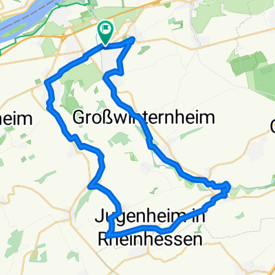
Ingelheim - Guldental - Wallhausen - Mandel - Waldböckelheim - Odernheim - Bad Münster - Fürfeld - Sprendlingen - Ingelheim
A cycling route starting in Ingelheim, Rhineland-Palatinate, Germany.
Overview
About this route
Start- & Zielort: Tennisheim
Ingelheim - Bingen Gaulsheim - Ockenheim - Bingen Büdesheim - Münster Sarmsheim - Laubenheim - Langenlonsheim - Guldental - Breitenfelser Hof - Gutenberg - Wallhausen - Sommerloch - Braunweiler - St. Katharinen - Mandel - Sponheim - Burgsponheim - Waldböckelheim - Oberstreit - Staudernheim - Odernheim am Glan - Duchroth - Oberhausen an der Nahe - Niederhausen - Norheim - Bad Münster - Altenbamberg - Steigerhof - Fürfeld - Neu Bamberg - Wöllstein - Badenheim - Sprendlingen - Ober Hilbersheim - Nieder Hilbersheim - Appenheim - Gau Algesheim - Ingelheim.- -:--
- Duration
- 118.1 km
- Distance
- 878 m
- Ascent
- 876 m
- Descent
- ---
- Avg. speed
- ---
- Max. altitude
Route quality
Waytypes & surfaces along the route
Waytypes
Busy road
75.8 km
(64 %)
Road
26.7 km
(23 %)
Surfaces
Paved
99.6 km
(84 %)
Unpaved
0.2 km
(<1 %)
Asphalt
96.2 km
(81 %)
Paved (undefined)
2.2 km
(2 %)
Continue with Bikemap
Use, edit, or download this cycling route
You would like to ride Ingelheim - Guldental - Wallhausen - Mandel - Waldböckelheim - Odernheim - Bad Münster - Fürfeld - Sprendlingen - Ingelheim or customize it for your own trip? Here is what you can do with this Bikemap route:
Free features
- Save this route as favorite or in collections
- Copy & plan your own version of this route
- Split it into stages to create a multi-day tour
- Sync your route with Garmin or Wahoo
Premium features
Free trial for 3 days, or one-time payment. More about Bikemap Premium.
- Navigate this route on iOS & Android
- Export a GPX / KML file of this route
- Create your custom printout (try it for free)
- Download this route for offline navigation
Discover more Premium features.
Get Bikemap PremiumFrom our community
Other popular routes starting in Ingelheim
 Ingelheim - Guldental - Wallhausen - Mandel - Waldböckelheim - Odernheim - Bad Münster - Fürfeld - Sprendlingen - Ingelheim
- Distance
- 118.1 km
- Ascent
- 878 m
- Descent
- 876 m
- Location
- Ingelheim, Rhineland-Palatinate, Germany
 011u Ingelheim - Wendelsheim - Pfaffen Schwabenheim - Ingelheim
- Distance
- 66.6 km
- Ascent
- 374 m
- Descent
- 308 m
- Location
- Ingelheim, Rhineland-Palatinate, Germany
 Ingelh-Walgalgesh-Windesh-Ingelh 3
- Distance
- 53 km
- Ascent
- 328 m
- Descent
- 327 m
- Location
- Ingelheim, Rhineland-Palatinate, Germany
 016d Ingelheim - Presberg - Bacharach - Rheinböllen - Stromberg - Ingelheim
- Distance
- 89.2 km
- Ascent
- 1,274 m
- Descent
- 1,258 m
- Location
- Ingelheim, Rhineland-Palatinate, Germany
 Zur Rausch 5
- Distance
- 18 km
- Ascent
- 241 m
- Descent
- 176 m
- Location
- Ingelheim, Rhineland-Palatinate, Germany
 32_Ingelheim – Jugenheim – Schwabenheim – Ingelheim
- Distance
- 35.6 km
- Ascent
- 262 m
- Descent
- 262 m
- Location
- Ingelheim, Rhineland-Palatinate, Germany
 Kreuz ud Quer durch schöne Rhoihesse !
- Distance
- 152.1 km
- Ascent
- 1,064 m
- Descent
- 1,064 m
- Location
- Ingelheim, Rhineland-Palatinate, Germany
 010c Ingelheim - Köngernheim - Undenheim - Ingelheim
- Distance
- 61 km
- Ascent
- 386 m
- Descent
- 325 m
- Location
- Ingelheim, Rhineland-Palatinate, Germany
Open it in the app