

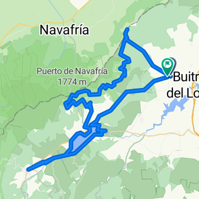
Lozoya-Rascafría-Navacerrada-Navafría-Lozoya
A cycling route starting in Villavieja del Lozoya, Madrid, Spain.
Overview
About this route
25 de Julio de 2013
- -:--
- Duration
- 125.4 km
- Distance
- 1,537 m
- Ascent
- 1,507 m
- Descent
- ---
- Avg. speed
- ---
- Max. altitude
Route quality
Waytypes & surfaces along the route
Waytypes
Cycleway
30.1 km
(24 %)
Track
12.5 km
(10 %)
Surfaces
Paved
67.7 km
(54 %)
Unpaved
1.3 km
(1 %)
Asphalt
65.2 km
(52 %)
Paved (undefined)
2.5 km
(2 %)
Continue with Bikemap
Use, edit, or download this cycling route
You would like to ride Lozoya-Rascafría-Navacerrada-Navafría-Lozoya or customize it for your own trip? Here is what you can do with this Bikemap route:
Free features
- Save this route as favorite or in collections
- Copy & plan your own version of this route
- Split it into stages to create a multi-day tour
- Sync your route with Garmin or Wahoo
Premium features
Free trial for 3 days, or one-time payment. More about Bikemap Premium.
- Navigate this route on iOS & Android
- Export a GPX / KML file of this route
- Create your custom printout (try it for free)
- Download this route for offline navigation
Discover more Premium features.
Get Bikemap PremiumFrom our community
Other popular routes starting in Villavieja del Lozoya
 Urbanización Los Llanos - La Horizontal
- Distance
- 23.3 km
- Ascent
- 814 m
- Descent
- 814 m
- Location
- Villavieja del Lozoya, Madrid, Spain
 gargantilla - 37k sube/baja
- Distance
- 36.8 km
- Ascent
- 437 m
- Descent
- 433 m
- Location
- Villavieja del Lozoya, Madrid, Spain
 gargantilla - 78 con navafria
- Distance
- 79.4 km
- Ascent
- 1,174 m
- Descent
- 1,167 m
- Location
- Villavieja del Lozoya, Madrid, Spain
 Villavieja de Lozoya-Pto. Linera
- Distance
- 46.4 km
- Ascent
- 925 m
- Descent
- 921 m
- Location
- Villavieja del Lozoya, Madrid, Spain
 Montes de Braojos
- Distance
- 27.6 km
- Ascent
- 723 m
- Descent
- 730 m
- Location
- Villavieja del Lozoya, Madrid, Spain
 Ruta en Villavieja del Lozoya
- Distance
- 79.6 km
- Ascent
- 1,843 m
- Descent
- 1,842 m
- Location
- Villavieja del Lozoya, Madrid, Spain
 gargantilla - 44k sube/baja
- Distance
- 43.7 km
- Ascent
- 579 m
- Descent
- 575 m
- Location
- Villavieja del Lozoya, Madrid, Spain
 Villavieja de Lozoya-Chorrera de San Mamés
- Distance
- 22 km
- Ascent
- 747 m
- Descent
- 747 m
- Location
- Villavieja del Lozoya, Madrid, Spain
Open it in the app