EDGE EXPLORE2®
Tag 45 über den "Parc Natural de la Marjal Pego-Oliva" nach Pego zum Kaffee...- 32.1 km
- 123 m
- 115 m
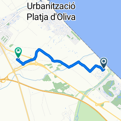
- Oliva, Valencia, Spain
A cycling route starting in Oliva, Valencia, Spain.
Overview
Start point: Oliva. Time cycling: 6 h. 15 m. Technical difficulty: Depending on sections, from 'Easy' to 'Experts only'. Physical difficulty: High. The route consists of three distinct parts. The first is a ride along agricultural paths from Rotova to Llocnou de Sant Jeroni, passing through Almiserà, following the course of the Vernissa river that must be crossed several times with the risk of being unable to if the water levels are high. The second part, quite demanding, is a circular route through the Sierra de Terrateig on a broken forest track but fully cyclable following the 'Ruta per les Penyes Albes', very well marked. There are several springs, recreational areas and places of interest to visit. The third part, reserved only for experts, runs from Terrateig to Castellonet de la Conquesta through the Sierra de La Cuta, recently devastated by fire. The forest track is very damaged and there are several sections that are not cyclable.
created this 12 years ago
Continue with Bikemap
You would like to ride oliva-rotova-terrateig-castellonet-gandia or customize it for your own trip? Here is what you can do with this Bikemap route:
Free trial for 3 days, or one-time payment. More about Bikemap Premium.
Discover more Premium features.
Get Bikemap PremiumFrom our community
EDGE EXPLORE2®
Tag 45 über den "Parc Natural de la Marjal Pego-Oliva" nach Pego zum Kaffee...Open it in the app