
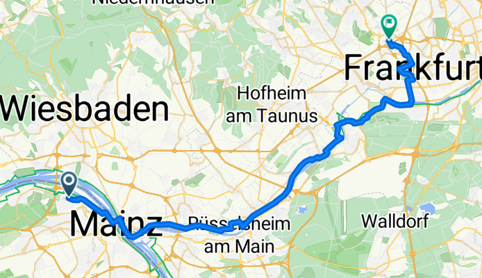
Mombach nach Eschborn
A cycling route starting in Budenheim, Rhineland-Palatinate, Germany.
Overview
About this route
Mombach nach Eschborn
- -:--
- Duration
- 45.3 km
- Distance
- 97 m
- Ascent
- 59 m
- Descent
- ---
- Avg. speed
- ---
- Max. altitude

Route quality
Waytypes & surfaces along the route
Waytypes
Track
15.5 km
(34 %)
Path
10.7 km
(24 %)
Surfaces
Paved
33.5 km
(74 %)
Unpaved
10 km
(22 %)
Asphalt
26.9 km
(59 %)
Gravel
7.5 km
(17 %)
Continue with Bikemap
Use, edit, or download this cycling route
You would like to ride Mombach nach Eschborn or customize it for your own trip? Here is what you can do with this Bikemap route:
Free features
- Save this route as favorite or in collections
- Copy & plan your own version of this route
- Sync your route with Garmin or Wahoo
Premium features
Free trial for 3 days, or one-time payment. More about Bikemap Premium.
- Navigate this route on iOS & Android
- Export a GPX / KML file of this route
- Create your custom printout (try it for free)
- Download this route for offline navigation
Discover more Premium features.
Get Bikemap PremiumFrom our community
Other popular routes starting in Budenheim
 Zum Kloster Jakobsberg - 71 km Permanente des RV Edelweiß 1910 Budenheim e.V.
- Distance
- 66.6 km
- Ascent
- 523 m
- Descent
- 523 m
- Location
- Budenheim, Rhineland-Palatinate, Germany
 Asphalt fressen im Grünen
- Distance
- 37 km
- Ascent
- 295 m
- Descent
- 295 m
- Location
- Budenheim, Rhineland-Palatinate, Germany
 RR-Tour durch Rheinhessen
- Distance
- 65.6 km
- Ascent
- 456 m
- Descent
- 456 m
- Location
- Budenheim, Rhineland-Palatinate, Germany
 MZ-Mombach - Heidenfahrt & zurück
- Distance
- 25.2 km
- Ascent
- 28 m
- Descent
- 26 m
- Location
- Budenheim, Rhineland-Palatinate, Germany
 Friedrichsstraße 50, Mainz nach Friedrichsstraße 50, Mainz
- Distance
- 17.3 km
- Ascent
- 43 m
- Descent
- 129 m
- Location
- Budenheim, Rhineland-Palatinate, Germany
 Rund Wiesbaden I
- Distance
- 54.7 km
- Ascent
- 620 m
- Descent
- 622 m
- Location
- Budenheim, Rhineland-Palatinate, Germany
 Rund um den Obst- u. Blütengarten Rheinhessen - RTF des RV Edelweiß 1910 Budenheim e.V. - 43 km Strecke
- Distance
- 42.2 km
- Ascent
- 168 m
- Descent
- 165 m
- Location
- Budenheim, Rhineland-Palatinate, Germany
 Gonsenheimer Waldtour
- Distance
- 17.4 km
- Ascent
- 163 m
- Descent
- 164 m
- Location
- Budenheim, Rhineland-Palatinate, Germany
Open it in the app