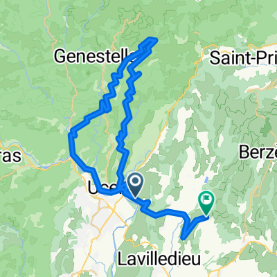
Francie2013-2
A cycling route starting in Saint-Privat, Auvergne-Rhône-Alpes, France.
Overview
About this route
<div>
Francie dovolená 3.den - 1.7. Okolo Aubenasu 2</div>
- -:--
- Duration
- 74.2 km
- Distance
- 800 m
- Ascent
- 800 m
- Descent
- ---
- Avg. speed
- ---
- Avg. speed
Route quality
Waytypes & surfaces along the route
Waytypes
Road
37.2 km
(50 %)
Busy road
21.1 km
(28 %)
Surfaces
Paved
47.5 km
(64 %)
Unpaved
1.6 km
(2 %)
Asphalt
47.5 km
(64 %)
Gravel
1.3 km
(2 %)
Continue with Bikemap
Use, edit, or download this cycling route
You would like to ride Francie2013-2 or customize it for your own trip? Here is what you can do with this Bikemap route:
Free features
- Save this route as favorite or in collections
- Copy & plan your own version of this route
- Sync your route with Garmin or Wahoo
Premium features
Free trial for 3 days, or one-time payment. More about Bikemap Premium.
- Navigate this route on iOS & Android
- Export a GPX / KML file of this route
- Create your custom printout (try it for free)
- Download this route for offline navigation
Discover more Premium features.
Get Bikemap PremiumFrom our community
Other popular routes starting in Saint-Privat
- 294B Chemin du Bosquet, Saint-Didier-sous-Aubenas à 2–8 Rue Jean Jaurès, Vals-les-Bains
- Distance
- 8.7 km
- Ascent
- 247 m
- Descent
- 177 m
- Location
- Saint-Privat, Auvergne-Rhône-Alpes, France
- Rondje in de Sud Ardeche
- Distance
- 38.1 km
- Ascent
- 647 m
- Descent
- 651 m
- Location
- Saint-Privat, Auvergne-Rhône-Alpes, France
- CHIROLS
- Distance
- 30.7 km
- Ascent
- 574 m
- Descent
- 523 m
- Location
- Saint-Privat, Auvergne-Rhône-Alpes, France
- 349 Chemin du Bosquet, Saint-Didier-sous-Aubenas à 414 Grand Rue Pons de Balazuc, Balazuc
- Distance
- 18.4 km
- Ascent
- 214 m
- Descent
- 249 m
- Location
- Saint-Privat, Auvergne-Rhône-Alpes, France
- Aubenas-Vallon-Pont-d`arc-col du serre de Tourre
- Distance
- 137.1 km
- Ascent
- 2,084 m
- Descent
- 2,085 m
- Location
- Saint-Privat, Auvergne-Rhône-Alpes, France
- Route de L’Echelette naar Route de L’Echelette 40-42
- Distance
- 45.3 km
- Ascent
- 2,368 m
- Descent
- 2,363 m
- Location
- Saint-Privat, Auvergne-Rhône-Alpes, France
- Lussas 35km
- Distance
- 34.7 km
- Ascent
- 781 m
- Descent
- 667 m
- Location
- Saint-Privat, Auvergne-Rhône-Alpes, France
- Gourdon
- Distance
- 33 km
- Ascent
- 544 m
- Descent
- 429 m
- Location
- Saint-Privat, Auvergne-Rhône-Alpes, France
Open it in the app