
Chambord 1
A cycling route starting in La Chapelle-Saint-Mesmin, Centre-Val de Loire, France.
Overview
About this route
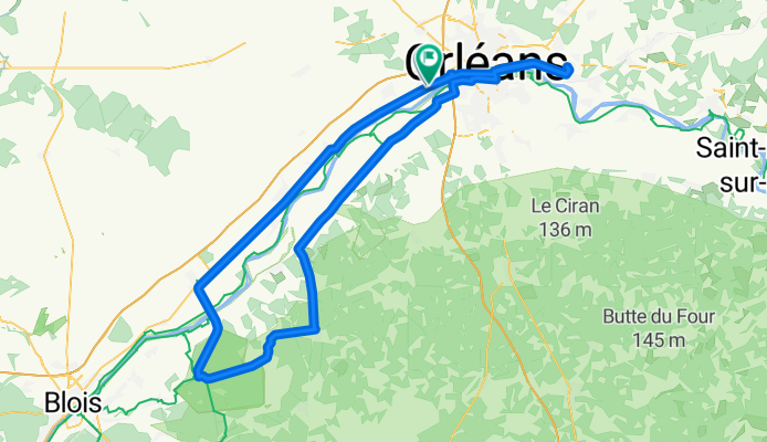
La Chapelle St Mesmin - Chamlbord - Orléans - Chécy - Orléans - La Chapelle St Mesmin
- -:--
- Duration
- 123.3 km
- Distance
- 125 m
- Ascent
- 131 m
- Descent
- ---
- Avg. speed
- ---
- Max. altitude

Route quality
Waytypes & surfaces along the route
Waytypes
Quiet road
17.3 km
(14 %)
Cycleway
13.6 km
(11 %)
Surfaces
Paved
78.9 km
(64 %)
Unpaved
3.7 km
(3 %)
Asphalt
77.6 km
(63 %)
Ground
2.5 km
(2 %)
Continue with Bikemap
Use, edit, or download this cycling route
You would like to ride Chambord 1 or customize it for your own trip? Here is what you can do with this Bikemap route:
Free features
- Save this route as favorite or in collections
- Copy & plan your own version of this route
- Split it into stages to create a multi-day tour
- Sync your route with Garmin or Wahoo
Premium features
Free trial for 3 days, or one-time payment. More about Bikemap Premium.
- Navigate this route on iOS & Android
- Export a GPX / KML file of this route
- Create your custom printout (try it for free)
- Download this route for offline navigation
Discover more Premium features.
Get Bikemap PremiumFrom our community
Other popular routes starting in La Chapelle-Saint-Mesmin
 De Rue nationale 2, La Chapelle-Saint-Mesmin à Rue de la Mairie 7, Muides-sur-Loire
- Distance
- 47.3 km
- Ascent
- 111 m
- Descent
- 132 m
- Location
- La Chapelle-Saint-Mesmin, Centre-Val de Loire, France
 Iti Nord Ouest 60.8k
- Distance
- 65.6 km
- Ascent
- 90 m
- Descent
- 93 m
- Location
- La Chapelle-Saint-Mesmin, Centre-Val de Loire, France
 Orléans (La Chapelle St Mesmin) - Briare
- Distance
- 86.3 km
- Ascent
- 153 m
- Descent
- 115 m
- Location
- La Chapelle-Saint-Mesmin, Centre-Val de Loire, France
 Chambord 1
- Distance
- 123.3 km
- Ascent
- 125 m
- Descent
- 131 m
- Location
- La Chapelle-Saint-Mesmin, Centre-Val de Loire, France
 Iti Nord Ouest 57k
- Distance
- 57.6 km
- Ascent
- 66 m
- Descent
- 63 m
- Location
- La Chapelle-Saint-Mesmin, Centre-Val de Loire, France
 14.Orléans-Etampes
- Distance
- 85.4 km
- Ascent
- 90 m
- Descent
- 128 m
- Location
- La Chapelle-Saint-Mesmin, Centre-Val de Loire, France
 Forêt d'Orléans
- Distance
- 57.8 km
- Ascent
- 87 m
- Descent
- 87 m
- Location
- La Chapelle-Saint-Mesmin, Centre-Val de Loire, France
 Loire
Loire- Distance
- 212.7 km
- Ascent
- 757 m
- Descent
- 834 m
- Location
- La Chapelle-Saint-Mesmin, Centre-Val de Loire, France
Open it in the app