

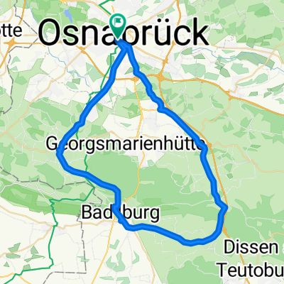
Teutoburger-Wald-Tour
A cycling route starting in Osnabrück, Lower Saxony, Germany.
Overview
About this route
90-km route starting from Osnabrück Hbf through the Teutoburg Forest over hilly terrain with some challenging climbs (up to 16% at Kleeberg) and a detour to Dörenberg (310 m; the Hermann Tower, 800 m off the route, offers a good view).
- -:--
- Duration
- 89 km
- Distance
- 917 m
- Ascent
- 917 m
- Descent
- ---
- Avg. speed
- ---
- Max. altitude
Route quality
Waytypes & surfaces along the route
Waytypes
Quiet road
36.5 km
(41 %)
Road
13.3 km
(15 %)
Surfaces
Paved
45.4 km
(51 %)
Unpaved
3.6 km
(4 %)
Asphalt
40.9 km
(46 %)
Paved (undefined)
4.4 km
(5 %)
Route highlights
Points of interest along the route
Point of interest after 11.6 km
Ellenberg (158 m; 34 hm; 0,52 km; 6,5%; max. 10%)
Point of interest after 16.8 km
Heidornberg (195 m; 75 hm; 1,5 km; 5,0%; max. 9%)
Point of interest after 21 km
Dörenberg (312 m; 112 hm; 1,7 km; 6,5%; max. 9%)
Point of interest after 35.5 km
Aldruper Berg (222 m; 109 hm; 2,3 km; 4,7%; max. 8%)
Point of interest after 50.1 km
Kleeberg (174 m; 50 hm; 0,5 km; 10%; max. 12%)
Point of interest after 51.2 km
Kleeberg (185 m; 64 hm; 0,5 km; 13%; max. 16%)
Point of interest after 55.1 km
Tecklenburg (186 m; 70 hm; 1,2 km; 5,9%; max. 9%)
Point of interest after 59.4 km
Brandenberg (202 m; 66 hm; 1,0 km; 6,6%; max. 12%)
Point of interest after 62.5 km
Brandenberg (199 m; 75 hm; 1,2 km; 6,3%; max. 11%)
Point of interest after 73.7 km
Jägerberg (164 m; 76 hm; 1,7 km; 4,5%; max. 8%)
Point of interest after 79.4 km
Schöppersiedl (192 m; 2,2 km; 99 hm; 4,5%; max. 12% bzw. 1,8 km; 80 hm; 4,4%; max. 10%)
Continue with Bikemap
Use, edit, or download this cycling route
You would like to ride Teutoburger-Wald-Tour or customize it for your own trip? Here is what you can do with this Bikemap route:
Free features
- Save this route as favorite or in collections
- Copy & plan your own version of this route
- Split it into stages to create a multi-day tour
- Sync your route with Garmin or Wahoo
Premium features
Free trial for 3 days, or one-time payment. More about Bikemap Premium.
- Navigate this route on iOS & Android
- Export a GPX / KML file of this route
- Create your custom printout (try it for free)
- Download this route for offline navigation
Discover more Premium features.
Get Bikemap PremiumFrom our community
Other popular routes starting in Osnabrück
 Liszthof, Osnabrück nach Liszthof, Osnabrück
- Distance
- 29.2 km
- Ascent
- 307 m
- Descent
- 306 m
- Location
- Osnabrück, Lower Saxony, Germany
 Osna Hilter Bad Osna
- Distance
- 45.2 km
- Ascent
- 409 m
- Descent
- 408 m
- Location
- Osnabrück, Lower Saxony, Germany
 Düte Runde von Osnabrück
- Distance
- 53.6 km
- Ascent
- 595 m
- Descent
- 593 m
- Location
- Osnabrück, Lower Saxony, Germany
 Vereinsausflug 2020 51km Rundtour Samstag
- Distance
- 50.5 km
- Ascent
- 414 m
- Descent
- 412 m
- Location
- Osnabrück, Lower Saxony, Germany
 Corneliusweg, Osnabrück nach Corneliusweg, Osnabrück
- Distance
- 65.2 km
- Ascent
- 608 m
- Descent
- 611 m
- Location
- Osnabrück, Lower Saxony, Germany
 Kleine Feierabendrunde
- Distance
- 26.6 km
- Ascent
- 139 m
- Descent
- 126 m
- Location
- Osnabrück, Lower Saxony, Germany
 Osn-Halen-Osn-4 Seen Tour
- Distance
- 31.4 km
- Ascent
- 132 m
- Descent
- 133 m
- Location
- Osnabrück, Lower Saxony, Germany
 Ausflug ins Grüne
- Distance
- 25.2 km
- Ascent
- 71 m
- Descent
- 67 m
- Location
- Osnabrück, Lower Saxony, Germany
Open it in the app