

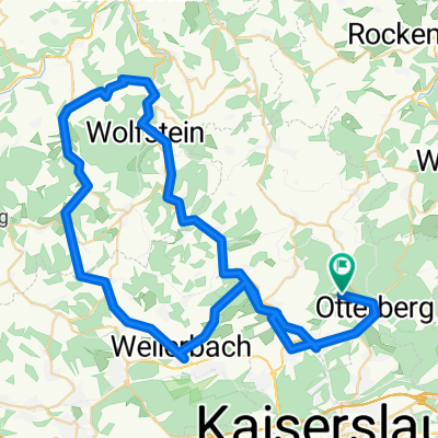
Tour Obermoschel
A cycling route starting in Otterberg, Rhineland-Palatinate, Germany.
Overview
About this route
Initially flat with beautiful climbs and wide streets
- -:--
- Duration
- 85.7 km
- Distance
- 554 m
- Ascent
- 611 m
- Descent
- ---
- Avg. speed
- ---
- Max. altitude
Route quality
Waytypes & surfaces along the route
Waytypes
Road
2.6 km
(3 %)
Quiet road
0.9 km
(1 %)
Surfaces
Paved
63.4 km
(74 %)
Asphalt
62.5 km
(73 %)
Paved (undefined)
0.9 km
(1 %)
Undefined
22.3 km
(26 %)
Continue with Bikemap
Use, edit, or download this cycling route
You would like to ride Tour Obermoschel or customize it for your own trip? Here is what you can do with this Bikemap route:
Free features
- Save this route as favorite or in collections
- Copy & plan your own version of this route
- Split it into stages to create a multi-day tour
- Sync your route with Garmin or Wahoo
Premium features
Free trial for 3 days, or one-time payment. More about Bikemap Premium.
- Navigate this route on iOS & Android
- Export a GPX / KML file of this route
- Create your custom printout (try it for free)
- Download this route for offline navigation
Discover more Premium features.
Get Bikemap PremiumFrom our community
Other popular routes starting in Otterberg
 Route nach KL in MZ und Helme gekauft!
- Distance
- 25.9 km
- Ascent
- 433 m
- Descent
- 408 m
- Location
- Otterberg, Rhineland-Palatinate, Germany
 28-AUG-11 01:26:19 PM
- Distance
- 7.5 km
- Ascent
- 141 m
- Descent
- 142 m
- Location
- Otterberg, Rhineland-Palatinate, Germany
 Althütter Straße 21, Otterberg nach Althütter Straße 21, Otterberg
- Distance
- 29.1 km
- Ascent
- 1,839 m
- Descent
- 1,835 m
- Location
- Otterberg, Rhineland-Palatinate, Germany
 gelterswoog vogelwoog
- Distance
- 22.5 km
- Ascent
- 870 m
- Descent
- 907 m
- Location
- Otterberg, Rhineland-Palatinate, Germany
 Lauerhof, Otterberg nach Lauerhof, Otterberg
- Distance
- 73 km
- Ascent
- 901 m
- Descent
- 899 m
- Location
- Otterberg, Rhineland-Palatinate, Germany
 zum Retzbergweiher und zurück
- Distance
- 40.6 km
- Ascent
- 706 m
- Descent
- 712 m
- Location
- Otterberg, Rhineland-Palatinate, Germany
 Site2Site Run 2: Otterberg > Mörschied
- Distance
- 66.7 km
- Ascent
- 775 m
- Descent
- 630 m
- Location
- Otterberg, Rhineland-Palatinate, Germany
 Mit Heinz und Steffi Schneider eine 1. Mai Fahrt.
- Distance
- 42.4 km
- Ascent
- 420 m
- Descent
- 386 m
- Location
- Otterberg, Rhineland-Palatinate, Germany
Open it in the app