

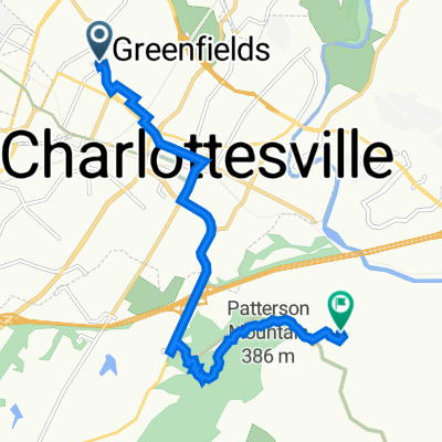
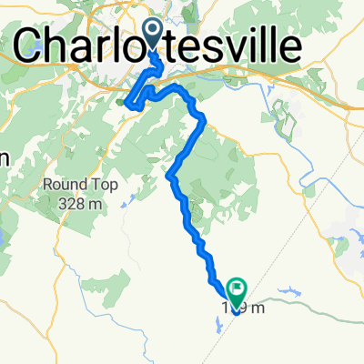
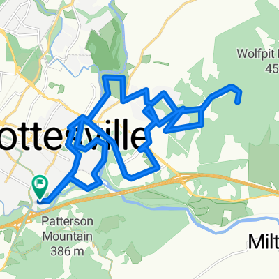
Open Loop w/Walnut Creek
A cycling route starting in Charlottesville, Virginia, United States.
Overview
About this route
Starts in Charlottesville, goes to Walnut Creek Park and ends in Glenmore.
- -:--
- Duration
- 44.5 km
- Distance
- 361 m
- Ascent
- 373 m
- Descent
- ---
- Avg. speed
- ---
- Max. altitude
Route quality
Waytypes & surfaces along the route
Waytypes
Road
23.1 km
(52 %)
Quiet road
9.3 km
(21 %)
Surfaces
Paved
12 km
(27 %)
Asphalt
12 km
(27 %)
Undefined
32.5 km
(73 %)
Continue with Bikemap
Use, edit, or download this cycling route
You would like to ride Open Loop w/Walnut Creek or customize it for your own trip? Here is what you can do with this Bikemap route:
Free features
- Save this route as favorite or in collections
- Copy & plan your own version of this route
- Sync your route with Garmin or Wahoo
Premium features
Free trial for 3 days, or one-time payment. More about Bikemap Premium.
- Navigate this route on iOS & Android
- Export a GPX / KML file of this route
- Create your custom printout (try it for free)
- Download this route for offline navigation
Discover more Premium features.
Get Bikemap PremiumFrom our community
Other popular routes starting in Charlottesville
 Monticello out and back
- Distance
- 10.3 km
- Ascent
- 245 m
- Descent
- 203 m
- Location
- Charlottesville, Virginia, United States
 USBR 76: Charlottesville to Lake Monticello
- Distance
- 28.8 km
- Ascent
- 415 m
- Descent
- 387 m
- Location
- Charlottesville, Virginia, United States
 Route in Charlottesville
- Distance
- 27.5 km
- Ascent
- 546 m
- Descent
- 547 m
- Location
- Charlottesville, Virginia, United States
 Route in Charlottesville
- Distance
- 29.5 km
- Ascent
- 729 m
- Descent
- 732 m
- Location
- Charlottesville, Virginia, United States
 Ivy Mudhouse
- Distance
- 53.8 km
- Ascent
- 788 m
- Descent
- 733 m
- Location
- Charlottesville, Virginia, United States
 Open Loop w/Walnut Creek
- Distance
- 44.5 km
- Ascent
- 361 m
- Descent
- 373 m
- Location
- Charlottesville, Virginia, United States
 Route in Charlottesville
- Distance
- 44.4 km
- Ascent
- 614 m
- Descent
- 615 m
- Location
- Charlottesville, Virginia, United States
 De Harvest Drive 164, Charlottesville a Harvest Drive 139, Charlottesville
- Distance
- 8.8 km
- Ascent
- 96 m
- Descent
- 97 m
- Location
- Charlottesville, Virginia, United States
Open it in the app