

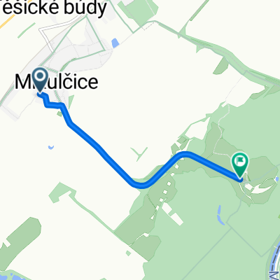
MORAVA-6.den-20.7.13
A cycling route starting in Mikulčice, South Moravian, Czechia.
Overview
About this route
Mikulčice - Moravská Nová Ves - Hrušky - Břeclav - Janův Hrad - Lednice - Rybniční zámeček - Lednické rybníky - Nový Dvůr -Tři Grácie - Ladenská alej - Svatý Hubert (kaple) - Randezvous - Valtice - Kolonáda na Reistně - Muzeum Železné opony - Úvaly - Sedlec u Mikulova - Mikulov
- -:--
- Duration
- 65.2 km
- Distance
- 244 m
- Ascent
- 232 m
- Descent
- ---
- Avg. speed
- ---
- Max. altitude

Route quality
Waytypes & surfaces along the route
Waytypes
Track
25 km
(38 %)
Quiet road
11.1 km
(17 %)
Surfaces
Paved
37.1 km
(57 %)
Unpaved
10.4 km
(16 %)
Asphalt
32.6 km
(50 %)
Gravel
7.4 km
(11 %)
Continue with Bikemap
Use, edit, or download this cycling route
You would like to ride MORAVA-6.den-20.7.13 or customize it for your own trip? Here is what you can do with this Bikemap route:
Free features
- Save this route as favorite or in collections
- Copy & plan your own version of this route
- Sync your route with Garmin or Wahoo
Premium features
Free trial for 3 days, or one-time payment. More about Bikemap Premium.
- Navigate this route on iOS & Android
- Export a GPX / KML file of this route
- Create your custom printout (try it for free)
- Download this route for offline navigation
Discover more Premium features.
Get Bikemap PremiumFrom our community
Other popular routes starting in Mikulčice
 Mikulčice, Mikulčice až Bažantnica, Holíč
- Distance
- 6.9 km
- Ascent
- 40 m
- Descent
- 35 m
- Location
- Mikulčice, South Moravian, Czechia
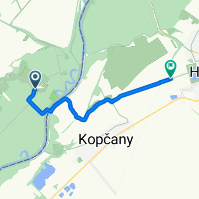
 Mikulčice -Kopčany
- Distance
- 20.5 km
- Ascent
- 130 m
- Descent
- 128 m
- Location
- Mikulčice, South Moravian, Czechia
 MORAVA-6.den-20.7.13
- Distance
- 65.2 km
- Ascent
- 244 m
- Descent
- 232 m
- Location
- Mikulčice, South Moravian, Czechia
 Mikulčice 738, Mikulčice až U Elektrárny 1–3, Hodonín
- Distance
- 8.2 km
- Ascent
- 197 m
- Descent
- 196 m
- Location
- Mikulčice, South Moravian, Czechia
 Mikulčice, Mikulčice do Mikulčice, Mikulčice
- Distance
- 3.9 km
- Ascent
- 9 m
- Descent
- 17 m
- Location
- Mikulčice, South Moravian, Czechia
 Silnice Bez Názvu do Chvalovice
- Distance
- 222.7 km
- Ascent
- 1,780 m
- Descent
- 1,759 m
- Location
- Mikulčice, South Moravian, Czechia
 na hnusny pivo do zizkova
- Distance
- 33.3 km
- Ascent
- 173 m
- Descent
- 175 m
- Location
- Mikulčice, South Moravian, Czechia
 pohansko2016
- Distance
- 50 km
- Ascent
- 135 m
- Descent
- 133 m
- Location
- Mikulčice, South Moravian, Czechia
Open it in the app