

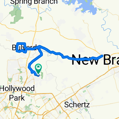
Bullis Cnty Park 20-miler loop
A cycling route starting in Timberwood Park, Texas, United States.
Overview
About this route
Starting at Bullis Cnty Park, head North on Blanco,
R on Specht L on Leron Von Scheele R on Ammann (dead end) L on Persimmon Hill to Hwy 46 R on Hwy 46 (short distance) R on Bulverde Rd. Bulverde South to city of Bulverde, TX R on Bulverde lane (at gas station, post office) R on Obst (turn into Specht Rd.) Follow original route to Blanco Rd. to Bullis Park- -:--
- Duration
- 30.3 km
- Distance
- 138 m
- Ascent
- 138 m
- Descent
- ---
- Avg. speed
- ---
- Max. altitude
Route quality
Waytypes & surfaces along the route
Waytypes
Road
18.5 km
(61 %)
Quiet road
7 km
(23 %)
Undefined
4.8 km
(16 %)
Surfaces
Paved
17.9 km
(59 %)
Asphalt
17.9 km
(59 %)
Undefined
12.4 km
(41 %)
Route highlights
Points of interest along the route
Point of interest after 3.9 km
Specht's Store; BBQ, beer, water, good times
Point of interest after 19.6 km
Bulverde, TX; water, gas station
Continue with Bikemap
Use, edit, or download this cycling route
You would like to ride Bullis Cnty Park 20-miler loop or customize it for your own trip? Here is what you can do with this Bikemap route:
Free features
- Save this route as favorite or in collections
- Copy & plan your own version of this route
- Sync your route with Garmin or Wahoo
Premium features
Free trial for 3 days, or one-time payment. More about Bikemap Premium.
- Navigate this route on iOS & Android
- Export a GPX / KML file of this route
- Create your custom printout (try it for free)
- Download this route for offline navigation
Discover more Premium features.
Get Bikemap PremiumFrom our community
Other popular routes starting in Timberwood Park
 Bullis Cnty Park 20-miler loop
- Distance
- 30.3 km
- Ascent
- 138 m
- Descent
- 138 m
- Location
- Timberwood Park, Texas, United States
 4092 TPC Pkwy, San Antonio to 4064–4080 Cibolo Canyon, San Antonio
- Distance
- 135 km
- Ascent
- 1,095 m
- Descent
- 1,090 m
- Location
- Timberwood Park, Texas, United States
 4092 TPC Pkwy, San Antonio to 4082–4098 Cibolo Canyon, San Antonio
- Distance
- 100.5 km
- Ascent
- 763 m
- Descent
- 758 m
- Location
- Timberwood Park, Texas, United States
 big 100 loop
- Distance
- 187.7 km
- Ascent
- 714 m
- Descent
- 714 m
- Location
- Timberwood Park, Texas, United States
 Slow ride in San Antonio
- Distance
- 4.7 km
- Ascent
- 43 m
- Descent
- 40 m
- Location
- Timberwood Park, Texas, United States
 4092 TPC Pkwy, San Antonio to 4082–4098 Cibolo Canyon, San Antonio
- Distance
- 122.2 km
- Ascent
- 514 m
- Descent
- 515 m
- Location
- Timberwood Park, Texas, United States
 Route to work
- Distance
- 41.9 km
- Ascent
- 105 m
- Descent
- 256 m
- Location
- Timberwood Park, Texas, United States
 Boerne Route
- Distance
- 77.2 km
- Ascent
- 327 m
- Descent
- 318 m
- Location
- Timberwood Park, Texas, United States
Open it in the app