

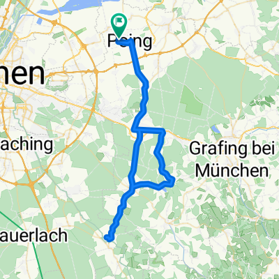
Rund um den Ebersberger Forst
A cycling route starting in Poing, Bavaria, Germany.
Overview
About this route
Beautiful route with one or two gravel sections around the Ebersberger Forst. Between Frauenneuharting and Maitenbeth, one could choose more secondary roads. An extension towards Wasserburg would also be nice.
- -:--
- Duration
- 85.2 km
- Distance
- 348 m
- Ascent
- 346 m
- Descent
- ---
- Avg. speed
- ---
- Max. altitude
Route quality
Waytypes & surfaces along the route
Waytypes
Quiet road
29 km
(34 %)
Road
27.3 km
(32 %)
Surfaces
Paved
72.5 km
(85 %)
Unpaved
11.1 km
(13 %)
Asphalt
72.5 km
(85 %)
Gravel
8.5 km
(10 %)
Continue with Bikemap
Use, edit, or download this cycling route
You would like to ride Rund um den Ebersberger Forst or customize it for your own trip? Here is what you can do with this Bikemap route:
Free features
- Save this route as favorite or in collections
- Copy & plan your own version of this route
- Split it into stages to create a multi-day tour
- Sync your route with Garmin or Wahoo
Premium features
Free trial for 3 days, or one-time payment. More about Bikemap Premium.
- Navigate this route on iOS & Android
- Export a GPX / KML file of this route
- Create your custom printout (try it for free)
- Download this route for offline navigation
Discover more Premium features.
Get Bikemap PremiumFrom our community
Other popular routes starting in Poing
 Poing - Forstern - Isen - MS - Poing
- Distance
- 54.8 km
- Ascent
- 275 m
- Descent
- 278 m
- Location
- Poing, Bavaria, Germany
 Poing Ebersbergerforst Poing
- Distance
- 46.2 km
- Ascent
- 153 m
- Descent
- 152 m
- Location
- Poing, Bavaria, Germany
 Rundfahrt nach Ebersberg
- Distance
- 44.8 km
- Ascent
- 134 m
- Descent
- 137 m
- Location
- Poing, Bavaria, Germany
 Speichersee und BMW Teststrecke (
- Distance
- 37.6 km
- Ascent
- 43 m
- Descent
- 43 m
- Location
- Poing, Bavaria, Germany
 Poing-Ebersberger Alm
- Distance
- 60 km
- Ascent
- 483 m
- Descent
- 483 m
- Location
- Poing, Bavaria, Germany
 Zur Bockerlbahn nach Assling
- Distance
- 71 km
- Ascent
- 380 m
- Descent
- 380 m
- Location
- Poing, Bavaria, Germany
 Abendrunde im Dunklen
- Distance
- 40.8 km
- Ascent
- 140 m
- Descent
- 141 m
- Location
- Poing, Bavaria, Germany
 Poing - Aying Biergarten - Poing Tour
- Distance
- 64.1 km
- Ascent
- 283 m
- Descent
- 280 m
- Location
- Poing, Bavaria, Germany
Open it in the app