

Armidale, Rockvale Rd Chandler Rd loop
A cycling route starting in Armidale, New South Wales, Australia.
Overview
About this route
This ride is a hilly workout, best done on a gravel bike as there is a significant sealed section, from the Lyndhurst Rd turnoff until about 7 km before Chandler Rd meets Rockvale road again. There is usually very little traffic apart from some commuter traffic morning and evening closer to Armidale. However, watch out for the odd B-double cattle truck as the road is narrow. Great views.
- -:--
- Duration
- 86.1 km
- Distance
- 772 m
- Ascent
- 773 m
- Descent
- ---
- Avg. speed
- ---
- Max. altitude

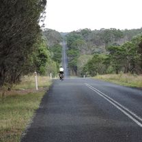
Route photos


Route quality
Waytypes & surfaces along the route
Waytypes
Road
63.6 km
(74 %)
Quiet road
16.5 km
(19 %)
Surfaces
Paved
62.1 km
(72 %)
Unpaved
24 km
(28 %)
Asphalt
58.9 km
(68 %)
Unpaved (undefined)
23.9 km
(28 %)
Continue with Bikemap
Use, edit, or download this cycling route
You would like to ride Armidale, Rockvale Rd Chandler Rd loop or customize it for your own trip? Here is what you can do with this Bikemap route:
Free features
- Save this route as favorite or in collections
- Copy & plan your own version of this route
- Split it into stages to create a multi-day tour
- Sync your route with Garmin or Wahoo
Premium features
Free trial for 3 days, or one-time payment. More about Bikemap Premium.
- Navigate this route on iOS & Android
- Export a GPX / KML file of this route
- Create your custom printout (try it for free)
- Download this route for offline navigation
Discover more Premium features.
Get Bikemap PremiumFrom our community
Other popular routes starting in Armidale
 Avoiding the Waterfall Way from Armidale
- Distance
- 92.5 km
- Ascent
- 708 m
- Descent
- 708 m
- Location
- Armidale, New South Wales, Australia
 Flat White
- Distance
- 19.5 km
- Ascent
- 203 m
- Descent
- 201 m
- Location
- Armidale, New South Wales, Australia
 Armidale to Point Lookout loop
- Distance
- 226.3 km
- Ascent
- 4,225 m
- Descent
- 4,225 m
- Location
- Armidale, New South Wales, Australia
 Armidale, Toms Gully, Puddledock loop
- Distance
- 71.6 km
- Ascent
- 607 m
- Descent
- 607 m
- Location
- Armidale, New South Wales, Australia
 Armidale, Rockvale Rd Chandler Rd loop
- Distance
- 86.1 km
- Ascent
- 772 m
- Descent
- 773 m
- Location
- Armidale, New South Wales, Australia
 Armidale to Uralla via Arding
- Distance
- 54.5 km
- Ascent
- 405 m
- Descent
- 396 m
- Location
- Armidale, New South Wales, Australia
 Apple tree drive loop for kids
- Distance
- 7.8 km
- Ascent
- 92 m
- Descent
- 93 m
- Location
- Armidale, New South Wales, Australia
 Armidale to Uralla via Hawthorne Dr
- Distance
- 72.4 km
- Ascent
- 463 m
- Descent
- 464 m
- Location
- Armidale, New South Wales, Australia
Open it in the app