

Valmontone-Capranica-Valmontone
A cycling route starting in Valmontone, Lazio, Italy.
Overview
About this route
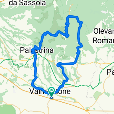
percorso molto bello, primo tratto caratterizzato da asfalto sporco e pieno di buche quindi bisogna fare molta attenzione, poi da Cave in su l'asfalto è bellissimo, i paesaggi mozzafiato, poco trafficata la strada; giunti a Capranica, punto più alto 881m, si scende velocemente dai bellissimi tornanti che portano fino a Palestrina e ancora giù fino a Loreto; poi qualche saliscendi fino a Valmontone.
- -:--
- Duration
- 51.3 km
- Distance
- 920 m
- Ascent
- 920 m
- Descent
- ---
- Avg. speed
- ---
- Max. altitude

Route quality
Waytypes & surfaces along the route
Waytypes
Road
24.7 km
(48 %)
Busy road
19.8 km
(39 %)
Surfaces
Paved
42.1 km
(82 %)
Unpaved
0.2 km
(<1 %)
Asphalt
42.1 km
(82 %)
Unpaved (undefined)
0.2 km
(<1 %)
Undefined
9 km
(17 %)
Continue with Bikemap
Use, edit, or download this cycling route
You would like to ride Valmontone-Capranica-Valmontone or customize it for your own trip? Here is what you can do with this Bikemap route:
Free features
- Save this route as favorite or in collections
- Copy & plan your own version of this route
- Sync your route with Garmin or Wahoo
Premium features
Free trial for 3 days, or one-time payment. More about Bikemap Premium.
- Navigate this route on iOS & Android
- Export a GPX / KML file of this route
- Create your custom printout (try it for free)
- Download this route for offline navigation
Discover more Premium features.
Get Bikemap PremiumFrom our community
Other popular routes starting in Valmontone
 JS_005 Motorrad Valmontone - Arsoli
- Distance
- 61.6 km
- Ascent
- 980 m
- Descent
- 672 m
- Location
- Valmontone, Lazio, Italy
 SERRONE
- Distance
- 21.5 km
- Ascent
- 347 m
- Descent
- 211 m
- Location
- Valmontone, Lazio, Italy
 Valm-Meta 1
- Distance
- 10.2 km
- Ascent
- 67 m
- Descent
- 104 m
- Location
- Valmontone, Lazio, Italy
 Test 30 min Rocca Massima
- Distance
- 54 km
- Ascent
- 759 m
- Descent
- 759 m
- Location
- Valmontone, Lazio, Italy
 Valmontone Piglio Arcinazzo Guarcino Fiuggi Paliano
- Distance
- 103 km
- Ascent
- 2,472 m
- Descent
- 2,472 m
- Location
- Valmontone, Lazio, Italy
 Valmontone-Capranica-Valmontone
- Distance
- 51.3 km
- Ascent
- 920 m
- Descent
- 920 m
- Location
- Valmontone, Lazio, Italy
 Cicloturistica Valmontone 01/10/2017
- Distance
- 34.9 km
- Ascent
- 557 m
- Descent
- 552 m
- Location
- Valmontone, Lazio, Italy
 Percorso MTB Vivaro da valmontone
- Distance
- 34.4 km
- Ascent
- 512 m
- Descent
- 512 m
- Location
- Valmontone, Lazio, Italy
Open it in the app