

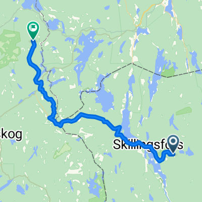
Från Håvilsrud till Austmarka över Mitanderfors till Håvilsrud
A cycling route starting in Charlottenberg, Värmland County, Sweden.
Overview
About this route
Start direkt an der norwegischen Grenze, schöner Parkplatz. Danach bis
Austmarka, Proviant im Laden gekauft. Hinter Mitandersfors an dem ersten Abzweig abbiegen nach Kyrkskogen. Nach ca. 4 km unscheinbarer Abzweig nach links zu Lilleken zu einem herrlichen Bade und Rastplatz mit Schutzhütte. Nach dem Baden , See ca. 24 Grad warm, weiter bis zur nächsten Kreuzung , rechts abbiegen Richtung Häljeboda danach bis yum Ausgangspunkt Parkplatz Grenze.- -:--
- Duration
- 50.5 km
- Distance
- 246 m
- Ascent
- 244 m
- Descent
- ---
- Avg. speed
- ---
- Max. altitude
Route quality
Waytypes & surfaces along the route
Waytypes
Road
16.7 km
(33 %)
Quiet road
6.6 km
(13 %)
Undefined
27.3 km
(54 %)
Surfaces
Paved
19.2 km
(38 %)
Unpaved
30.8 km
(61 %)
Gravel
27.3 km
(54 %)
Asphalt
19.2 km
(38 %)
Continue with Bikemap
Use, edit, or download this cycling route
You would like to ride Från Håvilsrud till Austmarka över Mitanderfors till Håvilsrud or customize it for your own trip? Here is what you can do with this Bikemap route:
Free features
- Save this route as favorite or in collections
- Copy & plan your own version of this route
- Sync your route with Garmin or Wahoo
Premium features
Free trial for 3 days, or one-time payment. More about Bikemap Premium.
- Navigate this route on iOS & Android
- Export a GPX / KML file of this route
- Create your custom printout (try it for free)
- Download this route for offline navigation
Discover more Premium features.
Get Bikemap PremiumFrom our community
Other popular routes starting in Charlottenberg
 Charlottenberg - Bjørkelangen
- Distance
- 31 km
- Ascent
- 570 m
- Descent
- 485 m
- Location
- Charlottenberg, Värmland County, Sweden
 Rangvald-Carola
- Distance
- 27.8 km
- Ascent
- 358 m
- Descent
- 380 m
- Location
- Charlottenberg, Värmland County, Sweden
 Från Håvilsrud till Austmarka över Mitanderfors till Håvilsrud
- Distance
- 50.5 km
- Ascent
- 246 m
- Descent
- 244 m
- Location
- Charlottenberg, Värmland County, Sweden
 Charlottenberg-Kongsv
- Distance
- 45.8 km
- Ascent
- 215 m
- Descent
- 193 m
- Location
- Charlottenberg, Värmland County, Sweden
 Värmland 5. Etappe
- Distance
- 42.7 km
- Ascent
- 322 m
- Descent
- 232 m
- Location
- Charlottenberg, Värmland County, Sweden
 2. Magnor-Sunne 73 km
- Distance
- 72.7 km
- Ascent
- 430 m
- Descent
- 494 m
- Location
- Charlottenberg, Värmland County, Sweden
 Charlottenbergsvägen 2A, Charlottenberg to Östra Hamngatan 45, Göteborg
- Distance
- 314.5 km
- Ascent
- 2,767 m
- Descent
- 2,880 m
- Location
- Charlottenberg, Värmland County, Sweden
 De Bönnäset à Fallanveien
- Distance
- 112.7 km
- Ascent
- 1,480 m
- Descent
- 1,443 m
- Location
- Charlottenberg, Värmland County, Sweden
Open it in the app