

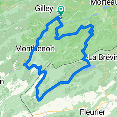
Basel - Nice, Tag 4 (Gilley - Saint-Point-Lac)
A cycling route starting in Gilley, Bourgogne-Franche-Comté, France.
Overview
About this route
Von Gilley bis Pontarlier folgt die Route einem alten Bahntrasse das zu einem Veloweg umfunktioniert wurde (teilweise unbefestigt)
- -:--
- Duration
- 40.8 km
- Distance
- 250 m
- Ascent
- 250 m
- Descent
- ---
- Avg. speed
- 887 m
- Max. altitude
Route quality
Waytypes & surfaces along the route
Waytypes
Path
18.8 km
(46 %)
Road
6.9 km
(17 %)
Surfaces
Paved
38 km
(93 %)
Asphalt
38 km
(93 %)
Undefined
2.9 km
(7 %)
Continue with Bikemap
Use, edit, or download this cycling route
You would like to ride Basel - Nice, Tag 4 (Gilley - Saint-Point-Lac) or customize it for your own trip? Here is what you can do with this Bikemap route:
Free features
- Save this route as favorite or in collections
- Copy & plan your own version of this route
- Sync your route with Garmin or Wahoo
Premium features
Free trial for 3 days, or one-time payment. More about Bikemap Premium.
- Navigate this route on iOS & Android
- Export a GPX / KML file of this route
- Create your custom printout (try it for free)
- Download this route for offline navigation
Discover more Premium features.
Get Bikemap PremiumFrom our community
Other popular routes starting in Gilley
 Le Théverot 3, Les Gras nach Le Théverot 3, Les Gras
- Distance
- 24.5 km
- Ascent
- 882 m
- Descent
- 884 m
- Location
- Gilley, Bourgogne-Franche-Comté, France
 2022 Bahntrasse pontarlier - Gilles
- Distance
- 6.6 km
- Ascent
- 57 m
- Descent
- 32 m
- Location
- Gilley, Bourgogne-Franche-Comté, France
 TdF - Gilley - Evillers - Gilley (60 km)
- Distance
- 60.2 km
- Ascent
- 967 m
- Descent
- 966 m
- Location
- Gilley, Bourgogne-Franche-Comté, France
 ETAPE 3 deLe Pont - Besançon - Le Doubs - Pontarlier - Le Pont
- Distance
- 71.3 km
- Ascent
- 510 m
- Descent
- 383 m
- Location
- Gilley, Bourgogne-Franche-Comté, France
 Route in Les Combes
- Distance
- 54.9 km
- Ascent
- 1,311 m
- Descent
- 1,307 m
- Location
- Gilley, Bourgogne-Franche-Comté, France
 De Le Haut Bois, Ville-du-Pont à Les Cottards 265, La Brévine
- Distance
- 12.1 km
- Ascent
- 433 m
- Descent
- 308 m
- Location
- Gilley, Bourgogne-Franche-Comté, France
 Autour de Montbenoit
- Distance
- 46.2 km
- Ascent
- 589 m
- Descent
- 594 m
- Location
- Gilley, Bourgogne-Franche-Comté, France
 Gilley-TdF-Gilley (68 km)
- Distance
- 68.1 km
- Ascent
- 1,601 m
- Descent
- 1,603 m
- Location
- Gilley, Bourgogne-Franche-Comté, France
Open it in the app