

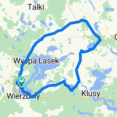
Orzysz, Pamry, Rydzewo, Orzysz
A cycling route starting in Orzysz, Warmian-Masurian Voivodeship, Poland.
Overview
About this route
Orzysz, Grądy Podmiejskie, Okrągłe, Talki, Pamry, Malinka, Czyprki, Miechy, Miłki, Wierciejki, Rydzewo, Jagodne Wielkie, Paprotki, Cierzpięty, Góra, Orzysz. Dystans - 69.3 km Wysokość min. - 116 m Wysokość maks. - 199 m Wznios - 545 m Spadek - 522 m
- -:--
- Duration
- 68.8 km
- Distance
- 230 m
- Ascent
- 228 m
- Descent
- ---
- Avg. speed
- ---
- Max. altitude
Route quality
Waytypes & surfaces along the route
Waytypes
Road
26 km
(38 %)
Quiet road
19.3 km
(28 %)
Surfaces
Paved
38.6 km
(56 %)
Unpaved
25.6 km
(37 %)
Asphalt
36.2 km
(53 %)
Gravel
16.2 km
(23 %)
Continue with Bikemap
Use, edit, or download this cycling route
You would like to ride Orzysz, Pamry, Rydzewo, Orzysz or customize it for your own trip? Here is what you can do with this Bikemap route:
Free features
- Save this route as favorite or in collections
- Copy & plan your own version of this route
- Sync your route with Garmin or Wahoo
Premium features
Free trial for 3 days, or one-time payment. More about Bikemap Premium.
- Navigate this route on iOS & Android
- Export a GPX / KML file of this route
- Create your custom printout (try it for free)
- Download this route for offline navigation
Discover more Premium features.
Get Bikemap PremiumFrom our community
Other popular routes starting in Orzysz
 Orzysz - Ełk side roads - bocznymi drogami
- Distance
- 71.6 km
- Ascent
- 203 m
- Descent
- 203 m
- Location
- Orzysz, Warmian-Masurian Voivodeship, Poland
 Kajka 2013
- Distance
- 35.9 km
- Ascent
- 207 m
- Descent
- 205 m
- Location
- Orzysz, Warmian-Masurian Voivodeship, Poland
 Orzysz, Pamry, Rydzewo, Orzysz
- Distance
- 68.8 km
- Ascent
- 230 m
- Descent
- 228 m
- Location
- Orzysz, Warmian-Masurian Voivodeship, Poland
 Wokół Jeziora Śniardwy. - Wokół Jeziora Śniardwy.
- Distance
- 90 km
- Ascent
- 526 m
- Descent
- 526 m
- Location
- Orzysz, Warmian-Masurian Voivodeship, Poland
 jezioro Orzysz
- Distance
- 40.5 km
- Ascent
- 578 m
- Descent
- 579 m
- Location
- Orzysz, Warmian-Masurian Voivodeship, Poland
 Orzysz - Konopki
- Distance
- 28.9 km
- Ascent
- 137 m
- Descent
- 139 m
- Location
- Orzysz, Warmian-Masurian Voivodeship, Poland
 Jezioro Buwełno
- Distance
- 42.7 km
- Ascent
- 133 m
- Descent
- 133 m
- Location
- Orzysz, Warmian-Masurian Voivodeship, Poland
 Polska 2014 Dzień 13
- Distance
- 49.7 km
- Ascent
- 137 m
- Descent
- 132 m
- Location
- Orzysz, Warmian-Masurian Voivodeship, Poland
Open it in the app