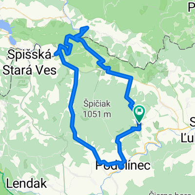
Magura
A cycling route starting in Vysne Ruzbachy, Prešov Region, Slovakia.
Overview
About this route
Magura
- -:--
- Duration
- 89.3 km
- Distance
- 777 m
- Ascent
- 783 m
- Descent
- ---
- Avg. speed
- ---
- Max. altitude
Route quality
Waytypes & surfaces along the route
Waytypes
Busy road
75 km
(84 %)
Road
5.5 km
(6 %)
Surfaces
Paved
72.9 km
(82 %)
Asphalt
72.7 km
(81 %)
Paving stones
0.1 km
(<1 %)
Undefined
16.4 km
(18 %)
Continue with Bikemap
Use, edit, or download this cycling route
You would like to ride Magura or customize it for your own trip? Here is what you can do with this Bikemap route:
Free features
- Save this route as favorite or in collections
- Copy & plan your own version of this route
- Split it into stages to create a multi-day tour
- Sync your route with Garmin or Wahoo
Premium features
Free trial for 3 days, or one-time payment. More about Bikemap Premium.
- Navigate this route on iOS & Android
- Export a GPX / KML file of this route
- Create your custom printout (try it for free)
- Download this route for offline navigation
Discover more Premium features.
Get Bikemap PremiumFrom our community
Other popular routes starting in Vysne Ruzbachy
- 21.04.2019 Pieniny, Spisz
- Distance
- 68.6 km
- Ascent
- 1,026 m
- Descent
- 1,026 m
- Location
- Vysne Ruzbachy, Prešov Region, Slovakia
- Vyšné Ružbachy do Unnamed Road, Vyšné Ružbachy
- Distance
- 2 km
- Ascent
- 18 m
- Descent
- 145 m
- Location
- Vysne Ruzbachy, Prešov Region, Slovakia
- Vyšné Ružbachy - Veterný vrch
- Distance
- 14.5 km
- Ascent
- 607 m
- Descent
- 216 m
- Location
- Vysne Ruzbachy, Prešov Region, Slovakia
- Popod Čiernu horu
- Distance
- 49 km
- Ascent
- 794 m
- Descent
- 794 m
- Location
- Vysne Ruzbachy, Prešov Region, Slovakia
- 20.04.2019 Góry Lewockie
- Distance
- 74.6 km
- Ascent
- 831 m
- Descent
- 832 m
- Location
- Vysne Ruzbachy, Prešov Region, Slovakia
- Veterný vrch
- Distance
- 20.5 km
- Ascent
- 589 m
- Descent
- 596 m
- Location
- Vysne Ruzbachy, Prešov Region, Slovakia
- Haligovce - Stará Ľubovńa - Litmanová - Biala Voda/PL/ - Jaworky/PL/ - Szczawnica/PL/ - lesnica - Prielom Dunajca - Červený Kláštor - Haligovce
- Distance
- 73.4 km
- Ascent
- 845 m
- Descent
- 845 m
- Location
- Vysne Ruzbachy, Prešov Region, Slovakia
- EBT 02 2015
- Distance
- 29.4 km
- Ascent
- 438 m
- Descent
- 628 m
- Location
- Vysne Ruzbachy, Prešov Region, Slovakia
Open it in the app