
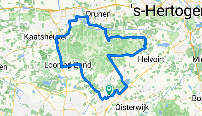
Rondje Drunense Duinen vanaf Berkel-Enschot
A cycling route starting in Oisterwijk, North Brabant, Netherlands.
Overview
About this route
Richting Biezenmortel/Cromvoirt/Giersbergen/Drunen/ Waalwijk/ Sprang / Kaatsheuvel / Langs Efteling / Loon op Zand / Den Hoek / retour Berkel-Enschot. Alles verharde weg. Klein stukje door wijk in Waalwijk en door Loon op Zand; rest vrije natuur.
- -:--
- Duration
- 45.9 km
- Distance
- 32 m
- Ascent
- 30 m
- Descent
- ---
- Avg. speed
- ---
- Max. altitude
Route quality
Waytypes & surfaces along the route
Waytypes
Quiet road
15.8 km
(34 %)
Road
13.1 km
(29 %)
Surfaces
Paved
27.2 km
(59 %)
Unpaved
0.2 km
(<1 %)
Asphalt
21.4 km
(47 %)
Paving stones
5.7 km
(12 %)
Route highlights
Points of interest along the route
Point of interest after 7.8 km
RUSTENDE JAGER, Groot terras. Oplaadpunt elektrische fietsen. Udenhoutse Broeder. Goeie Trappist.
Continue with Bikemap
Use, edit, or download this cycling route
You would like to ride Rondje Drunense Duinen vanaf Berkel-Enschot or customize it for your own trip? Here is what you can do with this Bikemap route:
Free features
- Save this route as favorite or in collections
- Copy & plan your own version of this route
- Sync your route with Garmin or Wahoo
Premium features
Free trial for 3 days, or one-time payment. More about Bikemap Premium.
- Navigate this route on iOS & Android
- Export a GPX / KML file of this route
- Create your custom printout (try it for free)
- Download this route for offline navigation
Discover more Premium features.
Get Bikemap PremiumFrom our community
Other popular routes starting in Oisterwijk
 Rondje Goirle Tilburg
- Distance
- 50 km
- Ascent
- 34 m
- Descent
- 36 m
- Location
- Oisterwijk, North Brabant, Netherlands
 Oisterwijk - Bergen op Zoom 114 km
- Distance
- 114.4 km
- Ascent
- 128 m
- Descent
- 133 m
- Location
- Oisterwijk, North Brabant, Netherlands
 Rondje Loonse en Drunense duinen vanuit Oisterwijk
- Distance
- 48 km
- Ascent
- 95 m
- Descent
- 94 m
- Location
- Oisterwijk, North Brabant, Netherlands
 Rond de Oisterwijkse bossen en vennen.
- Distance
- 46.4 km
- Ascent
- 27 m
- Descent
- 29 m
- Location
- Oisterwijk, North Brabant, Netherlands
 Moergstel - Vlagheide -Moergestel
- Distance
- 46.6 km
- Ascent
- 22 m
- Descent
- 23 m
- Location
- Oisterwijk, North Brabant, Netherlands
 Rondje Oisterwijk vennen Kampina stads centrum
- Distance
- 34.2 km
- Ascent
- 58 m
- Descent
- 58 m
- Location
- Oisterwijk, North Brabant, Netherlands
 Kasteel Nemerlaer – Landgoed de Velder -Kampina
- Distance
- 41.2 km
- Ascent
- 40 m
- Descent
- 31 m
- Location
- Oisterwijk, North Brabant, Netherlands
 Rund um Tilburg
- Distance
- 79.9 km
- Ascent
- 36 m
- Descent
- 36 m
- Location
- Oisterwijk, North Brabant, Netherlands
Open it in the app