

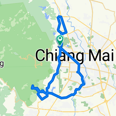
Mae Rim to Huay Tueng Tao Offroad
A cycling route starting in Chiang Mai, Chiang Mai, Thailand.
Overview
About this route
This is a 100% offroad ride predominantly on single track west of the military base in Mae Rim. Most of it runs through dense forest over undulating terrain. The trail is easy for the most part with some challenging sections (medium difficulty overall). The northern section beyond the lake has several stream crossings and g-outs dips with very deep ruts carved by years of motocross (ab-)use. The lake itself offers on-trail and off-trail riding along the shoreline with some bumps, drop-offs, guillies and other fun stuff. Just be imaginative and find your own line. On the weekend, there are many visitors at the lake.
- -:--
- Duration
- 12.8 km
- Distance
- 169 m
- Ascent
- 169 m
- Descent
- ---
- Avg. speed
- ---
- Max. altitude

Continue with Bikemap
Use, edit, or download this cycling route
You would like to ride Mae Rim to Huay Tueng Tao Offroad or customize it for your own trip? Here is what you can do with this Bikemap route:
Free features
- Save this route as favorite or in collections
- Copy & plan your own version of this route
- Sync your route with Garmin or Wahoo
Premium features
Free trial for 3 days, or one-time payment. More about Bikemap Premium.
- Navigate this route on iOS & Android
- Export a GPX / KML file of this route
- Create your custom printout (try it for free)
- Download this route for offline navigation
Discover more Premium features.
Get Bikemap PremiumFrom our community
Other popular routes starting in Chiang Mai
 Supersonic route in Chiang Mai
- Distance
- 11.7 km
- Ascent
- 160 m
- Descent
- 131 m
- Location
- Chiang Mai, Chiang Mai, Thailand
 Suthep, Chiang Mai nach National Highway 121, Chiang Mai
- Distance
- 14 km
- Ascent
- 39 m
- Descent
- 21 m
- Location
- Chiang Mai, Chiang Mai, Thailand
 Wat Doi Kam to 121 via 3029
- Distance
- 51.1 km
- Ascent
- 561 m
- Descent
- 532 m
- Location
- Chiang Mai, Chiang Mai, Thailand
 Chiang Mai - Huey Tueng Tao See
- Distance
- 39.5 km
- Ascent
- 101 m
- Descent
- 102 m
- Location
- Chiang Mai, Chiang Mai, Thailand
 straight to samoeng
- Distance
- 41.2 km
- Ascent
- 1,028 m
- Descent
- 849 m
- Location
- Chiang Mai, Chiang Mai, Thailand
 J19-chiang Maï - Mae kachan
- Distance
- 85.3 km
- Ascent
- 755 m
- Descent
- 480 m
- Location
- Chiang Mai, Chiang Mai, Thailand
 Chiang Mai City and Royal Floral Park (Motorbike)
- Distance
- 22.1 km
- Ascent
- 373 m
- Descent
- 379 m
- Location
- Chiang Mai, Chiang Mai, Thailand
 Mae Kuang and Mae Gnat
- Distance
- 123.6 km
- Ascent
- 1,059 m
- Descent
- 1,058 m
- Location
- Chiang Mai, Chiang Mai, Thailand
Open it in the app