

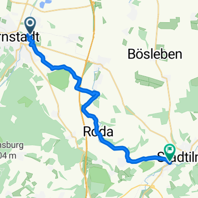
01 Geo-Route Arnstadt
A cycling route starting in Arnstadt, Free State of Thuringia, Germany.
Overview
About this route
Eine interessante Route die über das schöne Arnstädter Land führt.
- -:--
- Duration
- 17.2 km
- Distance
- 327 m
- Ascent
- 330 m
- Descent
- ---
- Avg. speed
- ---
- Max. altitude
Route highlights
Points of interest along the route
Point of interest after 1 km
Puppenmuseum
Point of interest after 1.4 km
Arnstadt-Information
Point of interest after 3.2 km
"Riesenlöffel", Ein 2,5mtr. hoher Bildstock! Genannt der "Riesenlöffel"
Point of interest after 4.1 km
Gipsbrüche
Point of interest after 6.8 km
Schottergrube
Point of interest after 6.8 km
Archäologisches Experimentiergelände Haarhausen
Point of interest after 7.8 km
"Bratwurstkreisel" mit Riesenbratwurst
Point of interest after 8.4 km
Erstes Deutsches Bratwurstmuseum!
Point of interest after 9.2 km
Riesengrill
Point of interest after 9.4 km
Die Kupferstrasse! Wir fahren auf der Kupferstrasse.
Point of interest after 9.5 km
Tongrube Bittstedt.
Continue with Bikemap
Use, edit, or download this cycling route
You would like to ride 01 Geo-Route Arnstadt or customize it for your own trip? Here is what you can do with this Bikemap route:
Free features
- Save this route as favorite or in collections
- Copy & plan your own version of this route
- Sync your route with Garmin or Wahoo
Premium features
Free trial for 3 days, or one-time payment. More about Bikemap Premium.
- Navigate this route on iOS & Android
- Export a GPX / KML file of this route
- Create your custom printout (try it for free)
- Download this route for offline navigation
Discover more Premium features.
Get Bikemap PremiumFrom our community
Other popular routes starting in Arnstadt
 Auf den Spuren Bachs die 2
- Distance
- 30.8 km
- Ascent
- 512 m
- Descent
- 567 m
- Location
- Arnstadt, Free State of Thuringia, Germany
 Plaue Walburgis Kloster zurück
- Distance
- 19.6 km
- Ascent
- 196 m
- Descent
- 197 m
- Location
- Arnstadt, Free State of Thuringia, Germany
 Radtour Arnstadt Stadtilm
- Distance
- 15.1 km
- Ascent
- 168 m
- Descent
- 69 m
- Location
- Arnstadt, Free State of Thuringia, Germany
 Arnstadt-Rennsteig und zurück
- Distance
- 90.3 km
- Ascent
- 1,129 m
- Descent
- 1,124 m
- Location
- Arnstadt, Free State of Thuringia, Germany
 01 Geo-Route Arnstadt
- Distance
- 17.2 km
- Ascent
- 327 m
- Descent
- 330 m
- Location
- Arnstadt, Free State of Thuringia, Germany
 Arnstadt Jonastal und zurück
- Distance
- 9.9 km
- Ascent
- 151 m
- Descent
- 153 m
- Location
- Arnstadt, Free State of Thuringia, Germany
 Hausrunde
- Distance
- 18.5 km
- Ascent
- 539 m
- Descent
- 537 m
- Location
- Arnstadt, Free State of Thuringia, Germany
 Hausrunde 2
- Distance
- 11.6 km
- Ascent
- 318 m
- Descent
- 315 m
- Location
- Arnstadt, Free State of Thuringia, Germany
Open it in the app