

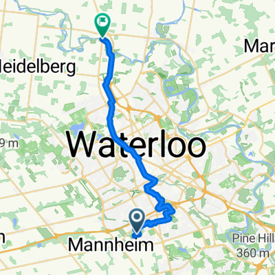
Sandhills Rebel Creek Loop 50km
A cycling route starting in Kitchener, Ontario, Canada.
Overview
About this route
Nice paved surface with plenty of shoulder. A little rough on Sand Hills Road.
- -:--
- Duration
- 50.6 km
- Distance
- 261 m
- Ascent
- 261 m
- Descent
- ---
- Avg. speed
- ---
- Max. altitude

Route quality
Waytypes & surfaces along the route
Waytypes
Busy road
31.4 km
(62 %)
Road
17.8 km
(35 %)
Surfaces
Paved
34.4 km
(68 %)
Asphalt
32.6 km
(64 %)
Paved (undefined)
1.8 km
(4 %)
Undefined
16.2 km
(32 %)
Continue with Bikemap
Use, edit, or download this cycling route
You would like to ride Sandhills Rebel Creek Loop 50km or customize it for your own trip? Here is what you can do with this Bikemap route:
Free features
- Save this route as favorite or in collections
- Copy & plan your own version of this route
- Sync your route with Garmin or Wahoo
Premium features
Free trial for 3 days, or one-time payment. More about Bikemap Premium.
- Navigate this route on iOS & Android
- Export a GPX / KML file of this route
- Create your custom printout (try it for free)
- Download this route for offline navigation
Discover more Premium features.
Get Bikemap PremiumFrom our community
Other popular routes starting in Kitchener
 Sandhills Rebel Creek Loop 50km
- Distance
- 50.6 km
- Ascent
- 261 m
- Descent
- 261 m
- Location
- Kitchener, Ontario, Canada
 Bloomingdale
- Distance
- 51.8 km
- Ascent
- 172 m
- Descent
- 173 m
- Location
- Kitchener, Ontario, Canada
 Monarch Woods Dr, Kitchener to Monarch Woods Dr, Kitchener
- Distance
- 9.6 km
- Ascent
- 171 m
- Descent
- 165 m
- Location
- Kitchener, Ontario, Canada
 Hydrocut Time Trial
- Distance
- 15.2 km
- Ascent
- 208 m
- Descent
- 206 m
- Location
- Kitchener, Ontario, Canada
 Monarch Woods Dr, Kitchener to Monarch Woods Dr, Kitchener
- Distance
- 11.4 km
- Ascent
- 141 m
- Descent
- 150 m
- Location
- Kitchener, Ontario, Canada
 Monarch Woods Dr, Kitchener
- Distance
- 11.9 km
- Ascent
- 126 m
- Descent
- 113 m
- Location
- Kitchener, Ontario, Canada
 From Kitchener to Saint Jacobs
- Distance
- 24.2 km
- Ascent
- 114 m
- Descent
- 146 m
- Location
- Kitchener, Ontario, Canada
 Monarch Woods Dr, Kitchener to Monarch Woods Dr, Kitchener
- Distance
- 26.6 km
- Ascent
- 250 m
- Descent
- 253 m
- Location
- Kitchener, Ontario, Canada
Open it in the app