

Přírodním parkem Březná
A cycling route starting in Zábřeh, Olomoucký kraj, Czechia.
Overview
About this route
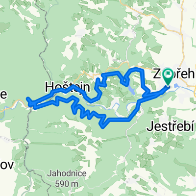
The route through the Březná Nature Park starts in Zábřeh na Moravě, from where it leads past the Nemilka reservoir and ascends from the Růžové valley to the northernmost part, which is the village of Štíty. The return route goes through the beautiful Březná valley and the Moravian Sázava.
- -:--
- Duration
- 46.1 km
- Distance
- 524 m
- Ascent
- 521 m
- Descent
- ---
- Avg. speed
- ---
- Max. altitude
Route highlights
Points of interest along the route

Point of interest after 2.7 km

Point of interest after 6.2 km

Point of interest after 8.8 km

Point of interest after 9.8 km

Point of interest after 18.4 km
Continue with Bikemap
Use, edit, or download this cycling route
You would like to ride Přírodním parkem Březná or customize it for your own trip? Here is what you can do with this Bikemap route:
Free features
- Save this route as favorite or in collections
- Copy & plan your own version of this route
- Sync your route with Garmin or Wahoo
Premium features
Free trial for 3 days, or one-time payment. More about Bikemap Premium.
- Navigate this route on iOS & Android
- Export a GPX / KML file of this route
- Create your custom printout (try it for free)
- Download this route for offline navigation
Discover more Premium features.
Get Bikemap PremiumFrom our community
Other popular routes starting in Zábřeh
 Welzlovo kolo "35"
- Distance
- 33.9 km
- Ascent
- 655 m
- Descent
- 660 m
- Location
- Zábřeh, Olomoucký kraj, Czechia
 Zbr-Maletín-Dolní Bušínov-Zbr
- Distance
- 30.4 km
- Ascent
- 468 m
- Descent
- 469 m
- Location
- Zábřeh, Olomoucký kraj, Czechia
 Zbr-Staré Město - Maletín-Zbr
- Distance
- 57 km
- Ascent
- 458 m
- Descent
- 458 m
- Location
- Zábřeh, Olomoucký kraj, Czechia
 Zábřeh - Petříkov
- Distance
- 45.4 km
- Ascent
- 788 m
- Descent
- 377 m
- Location
- Zábřeh, Olomoucký kraj, Czechia
 Dolní Bušínov - Mírov a zpátky
- Distance
- 15.2 km
- Ascent
- 324 m
- Descent
- 324 m
- Location
- Zábřeh, Olomoucký kraj, Czechia
 Zbr-Brníčko-Hrabišín-Špk-Sudkov-Zbr
- Distance
- 34.7 km
- Ascent
- 130 m
- Descent
- 131 m
- Location
- Zábřeh, Olomoucký kraj, Czechia
 Přírodním parkem Březná
- Distance
- 46.1 km
- Ascent
- 524 m
- Descent
- 521 m
- Location
- Zábřeh, Olomoucký kraj, Czechia
 Trofeo Monte Altvater 2020
- Distance
- 155.6 km
- Ascent
- 3,425 m
- Descent
- 3,144 m
- Location
- Zábřeh, Olomoucký kraj, Czechia
Open it in the app