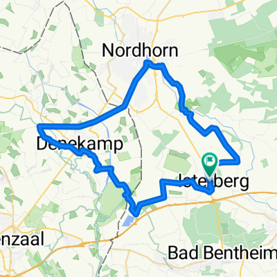
CE_130727
A cycling route starting in Isterberg, Lower Saxony, Germany.
Overview
About this route
gemischt wegstrecke mit vielen schattigen Passagen. Auch eine Sandstrecke durch das Heidegebiet.
- -:--
- Duration
- 42.8 km
- Distance
- 38 m
- Ascent
- 40 m
- Descent
- ---
- Avg. speed
- ---
- Avg. speed
Route quality
Waytypes & surfaces along the route
Waytypes
Quiet road
24.5 km
(57 %)
Road
7.1 km
(17 %)
Surfaces
Paved
27.9 km
(65 %)
Unpaved
7.1 km
(17 %)
Asphalt
27 km
(63 %)
Loose gravel
5.3 km
(12 %)
Continue with Bikemap
Use, edit, or download this cycling route
You would like to ride CE_130727 or customize it for your own trip? Here is what you can do with this Bikemap route:
Free features
- Save this route as favorite or in collections
- Copy & plan your own version of this route
- Sync your route with Garmin or Wahoo
Premium features
Free trial for 3 days, or one-time payment. More about Bikemap Premium.
- Navigate this route on iOS & Android
- Export a GPX / KML file of this route
- Create your custom printout (try it for free)
- Download this route for offline navigation
Discover more Premium features.
Get Bikemap PremiumFrom our community
Other popular routes starting in Isterberg
- CE_130727
- Distance
- 42.8 km
- Ascent
- 38 m
- Descent
- 40 m
- Location
- Isterberg, Lower Saxony, Germany
- 20_2023_Grensoverschrijdende_Theetuinen_Noord
- Distance
- 42.7 km
- Ascent
- 200 m
- Descent
- 199 m
- Location
- Isterberg, Lower Saxony, Germany
- Bramhaar 1, Isterberg nach Rheiner Straße 7A, Bad Bentheim
- Distance
- 9.5 km
- Ascent
- 57 m
- Descent
- 91 m
- Location
- Isterberg, Lower Saxony, Germany
- 6. Grafschafter Anfietsen: Tour Bad Bentheim & Schüttorf -Wietmarschen
- Distance
- 27.6 km
- Ascent
- 26 m
- Descent
- 35 m
- Location
- Isterberg, Lower Saxony, Germany
- GFT4
- Distance
- 33.7 km
- Ascent
- 59 m
- Descent
- 59 m
- Location
- Isterberg, Lower Saxony, Germany
- GFT 4_Hochwasserstrecke
- Distance
- 32.7 km
- Ascent
- 55 m
- Descent
- 53 m
- Location
- Isterberg, Lower Saxony, Germany
- Tagesroute 5
- Distance
- 48.1 km
- Ascent
- 41 m
- Descent
- 41 m
- Location
- Isterberg, Lower Saxony, Germany
- N&F 2. Engdener Wüste herum
- Distance
- 51.5 km
- Ascent
- 77 m
- Descent
- 80 m
- Location
- Isterberg, Lower Saxony, Germany
Open it in the app