

MonteCucco
A cycling route starting in Sigillo, Umbria, Italy.
Overview
About this route
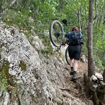
giro 'fresco' quasi tutto all'ombra. ok per il tracking, si puo' fare anche in mtb, ma è corto.
- -:--
- Duration
- 7.9 km
- Distance
- 477 m
- Ascent
- 501 m
- Descent
- ---
- Avg. speed
- ---
- Max. altitude
Continue with Bikemap
Use, edit, or download this cycling route
You would like to ride MonteCucco or customize it for your own trip? Here is what you can do with this Bikemap route:
Free features
- Save this route as favorite or in collections
- Copy & plan your own version of this route
- Sync your route with Garmin or Wahoo
Premium features
Free trial for 3 days, or one-time payment. More about Bikemap Premium.
- Navigate this route on iOS & Android
- Export a GPX / KML file of this route
- Create your custom printout (try it for free)
- Download this route for offline navigation
Discover more Premium features.
Get Bikemap PremiumFrom our community
Other popular routes starting in Sigillo
 Alto chiascio Gubbio-Assisi-Gualdo
- Distance
- 121.8 km
- Ascent
- 1,620 m
- Descent
- 1,620 m
- Location
- Sigillo, Umbria, Italy
 Cima Filetta da Purello
- Distance
- 11.1 km
- Ascent
- 813 m
- Descent
- 814 m
- Location
- Sigillo, Umbria, Italy
 Tobia-Cucco da PC
- Distance
- 11.8 km
- Ascent
- 705 m
- Descent
- 686 m
- Location
- Sigillo, Umbria, Italy
 Da Via Flaminia 35, Sigillo a Via Flaminia 35, Sigillo
- Distance
- 46.9 km
- Ascent
- 1,955 m
- Descent
- 1,955 m
- Location
- Sigillo, Umbria, Italy
 Via del Ranco 2, Val di Ranco nach Via del Ranco 2, Val di Ranco
- Distance
- 26 km
- Ascent
- 713 m
- Descent
- 981 m
- Location
- Sigillo, Umbria, Italy
 MonteCucco
- Distance
- 7.9 km
- Ascent
- 477 m
- Descent
- 501 m
- Location
- Sigillo, Umbria, Italy
 Ritrata - Monte Nerone
- Distance
- 158.1 km
- Ascent
- 4,565 m
- Descent
- 3,635 m
- Location
- Sigillo, Umbria, Italy
 Monte Cucco
- Distance
- 5.4 km
- Ascent
- 181 m
- Descent
- 181 m
- Location
- Sigillo, Umbria, Italy
Open it in the app