

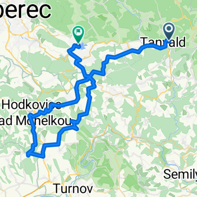
Tanvald - Jelena Gora
A cycling route starting in Tanvald, Liberecký kraj, Czechia.
Overview
About this route
Cycling trip Tanvald - Jelena Gora
- -:--
- Duration
- 48 km
- Distance
- 628 m
- Ascent
- 740 m
- Descent
- ---
- Avg. speed
- ---
- Max. altitude

Route quality
Waytypes & surfaces along the route
Waytypes
Road
16.3 km
(34 %)
Track
6.7 km
(14 %)
Surfaces
Paved
36 km
(75 %)
Unpaved
7.7 km
(16 %)
Asphalt
35.5 km
(74 %)
Gravel
4.3 km
(9 %)
Continue with Bikemap
Use, edit, or download this cycling route
You would like to ride Tanvald - Jelena Gora or customize it for your own trip? Here is what you can do with this Bikemap route:
Free features
- Save this route as favorite or in collections
- Copy & plan your own version of this route
- Sync your route with Garmin or Wahoo
Premium features
Free trial for 3 days, or one-time payment. More about Bikemap Premium.
- Navigate this route on iOS & Android
- Export a GPX / KML file of this route
- Create your custom printout (try it for free)
- Download this route for offline navigation
Discover more Premium features.
Get Bikemap PremiumFrom our community
Other popular routes starting in Tanvald
 1. etapa - sobota 31.5.2014 - cca 90km
- Distance
- 89.9 km
- Ascent
- 276 m
- Descent
- 552 m
- Location
- Tanvald, Liberecký kraj, Czechia
 Zlaťák clasic
- Distance
- 83 km
- Ascent
- 1,877 m
- Descent
- 1,877 m
- Location
- Tanvald, Liberecký kraj, Czechia
 šumburk-semily-kozákov-ž.brod-bozkov-žumburk
- Distance
- 81.4 km
- Ascent
- 1,664 m
- Descent
- 1,529 m
- Location
- Tanvald, Liberecký kraj, Czechia
 Sychrov
- Distance
- 54.9 km
- Ascent
- 755 m
- Descent
- 748 m
- Location
- Tanvald, Liberecký kraj, Czechia
 K přehradě Josefův důl a ještě jednou protržená přehrada a do třetice přehrada Souš
- Distance
- 50.5 km
- Ascent
- 950 m
- Descent
- 949 m
- Location
- Tanvald, Liberecký kraj, Czechia
 Rund um das Iser-Gebirge
- Distance
- 76.3 km
- Ascent
- 714 m
- Descent
- 922 m
- Location
- Tanvald, Liberecký kraj, Czechia
 Po Jizerských loučkách
- Distance
- 58.6 km
- Ascent
- 901 m
- Descent
- 909 m
- Location
- Tanvald, Liberecký kraj, Czechia
 Tanvald - Železný Brod - Malá Skála - Kopanina - Císařův kámen - Liberec
- Distance
- 68.1 km
- Ascent
- 1,116 m
- Descent
- 1,212 m
- Location
- Tanvald, Liberecký kraj, Czechia
Open it in the app